IMAGES TAKEN NEAR TO
Bissoe, TRURO, TR4 8ST
Introduction
This page details the photographs taken nearby to TR4 8ST by members of the Geograph project.
The Geograph project started in 2005 with the aim of publishing, organising and preserving representative images for every square kilometre of Great Britain, Ireland and the Isle of Man.

There are currently over 7.5m images from over14,400 individuals and you can help contribute to the project by visiting https://www.geograph.org.uk
Image Map
Images are licensed for reuse under creativecommons.org/licenses/by-sa/2.0
Notes
- Clicking on the map will re-center to the selected point.
- The higher the marker number, the further away the image location is from the centre of the postcode.
Image Listing (20 Images Found)
Images are licensed for reuse under creativecommons.org/licenses/by-sa/2.0
Image
Details
Distance
1
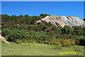
Mining Area
Part of an Equestrion and Cycling centre
Image: © mike hancock
Taken: 28 Aug 2005
0.04 miles
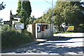
2

Old Direction Sign - Signpost by junction in Bissoe, Kea parish
Pyramid spear finial - obscured by later aluminium sign; Cornwall CC iron spear by the UC road, in parish of Kea (Carrick District), Chacewater turn, Bissoe, in hedge.
Surveyed
Milestone Society National ID: CW_SW7741
Image: © Milestone Society
Taken: Unknown
0.05 miles
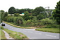
4
Bus stop at Bissoe
Also in the picture is an Elizabeth II post box, the village notice board, old and new style signposts.
Image: © Fred James
Taken: 12 Oct 2009
0.05 miles
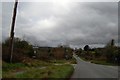
6
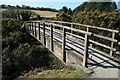
Footbridge near Bissoe
This footbridge carries the Carnon Valley Trail over the Carnon River just south of Bissoe village.
Image: © John Gibson
Taken: 17 Mar 2009
0.10 miles
7
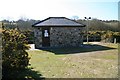
Bissoe Gauging Station
This Environment Agency water gauging station sits on the River Carnon near Bissoe and is used to monitor the state of the watercourse. The 8-digit NGR is helpfully identified on the door to the building.
Image: © John Gibson
Taken: 17 Mar 2009
0.10 miles
8
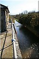
Gauging Station near Bissoe
Like its partner downstream, the Bissoe Gauging Station is used by the Environment Agency to monitor the condition of the watercourse, covering water levels, rate of flow, temperature and pollution, the latter being particularly important in this former mining area.
Image: © John Gibson
Taken: 17 Mar 2009
0.10 miles
9
Lush Vegetation by the Carnon River
Looking over the parapet of a road bridge.
Image: © Tony Atkin
Taken: 14 Jun 2008
0.13 miles
10
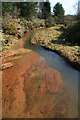
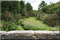
Carnon River pollution
The Carnon River is heavily polluted with iron hydroxides and a mix of heavy metals, a legacy of the intensive metal mining in this area, which has what is reported to be the highest ground arsenic count in the world. The impact is clear at this point in the river, although a variety of river grasses and plants seem to be happy enough in spite of the pollutants.
Image: © John Gibson
Taken: 17 Mar 2009
0.15 miles