IMAGES TAKEN NEAR TO
Point Mills, Chacewater, TRURO, TR4 8RA
Introduction
This page details the photographs taken nearby to TR4 8RA by members of the Geograph project.
The Geograph project started in 2005 with the aim of publishing, organising and preserving representative images for every square kilometre of Great Britain, Ireland and the Isle of Man.

There are currently over 7.5m images from over14,400 individuals and you can help contribute to the project by visiting https://www.geograph.org.uk
Image Map
Images are licensed for reuse under creativecommons.org/licenses/by-sa/2.0
Notes
- Clicking on the map will re-center to the selected point.
- The higher the marker number, the further away the image location is from the centre of the postcode.
Image Listing (13 Images Found)
Images are licensed for reuse under creativecommons.org/licenses/by-sa/2.0
Image
Details
Distance
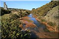
1
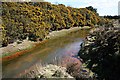
Carnon River at Bissoe
The river level is high due to recent rains. Red mineral staining can be seen on the grass at the river's edge due to minerals being washed out into the river upstream. The land here is contaminated with arsenic which is also probably being leached into the river. The river itself does not look unhealthy, which plenty of weed in the river bed, but I would not like to drink it!
Image: © Tony Atkin
Taken: 6 Apr 2006
0.05 miles
2
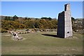
Point Mills Arsenic Refinery
These ruins are all that remains of the refinery which operated from around 1840 to 1939.
Image: © Tony Atkin
Taken: 6 Apr 2006
0.05 miles
4
Bissoe
The former Mineral Tramways around Bissoe have been converted into a series of cycle paths through the former mining district. Much industrial dereliction remains and parts of the area are still heavily poisoned with arsenic and other unpleasant materials but it is slowing reverting to nature. The mine on the hilltop is Mount Wellington Mine, sadly closed.
Image: © Ron Strutt
Taken: 9 Sep 2003
0.06 miles
5
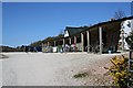
Cycle Hire and Cafe on the old tramway
An example of how industrial devastation has turned into a tourism opportunity. The old mineral tramway along the Carnon River Valley has been made a cycleway. With the scars of 19th century mining now covered by vegetation, this area has become something which tourists want to experience.
Image: © Tony Atkin
Taken: 6 Apr 2006
0.06 miles
6
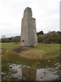
Chimney, Point Mills Arsenic Refinery, Bissoe
Image: © Chris Andrews
Taken: 15 Feb 2012
0.09 miles
7
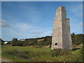
Remains of Point Mills Arsenic Refinery
The British Arsenic Company, which later became the Cornwall Arsenic Company, operated these works for a century, ending with the outbreak of WW2. The production of arsenic was a by product of tin smelting (more information here: http://www.pznow.co.uk/historic1/tin5.html ). The arsenic from these works was noted for its high quality and was exported for use in cotton plantations to control boll weevil. After the refinery closed the site remained derelict until it was landscaped to form a public recreational area in 1986.
Image: © Rod Allday
Taken: 3 Oct 2008
0.11 miles
8
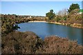
Bissoe Valley Nature Reserve
One of two modern ponds created when the Nature Reserve was established in 1986. The pond is surrounded by rushes, iris, heather and gorse, and is home to the 12 recorded species of dragonfly and damselfly, as well as frogs, toads and newts. A key aim of the nature reserve is to monitor and research the effects of heavy metal contamination from mine wastes, including the spoil from the nearby Point Mills Arsenic Refinery.
Image: © John Gibson
Taken: 17 Mar 2009
0.13 miles
9
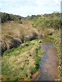
Carnon River near Point Mills
Pollution from mine waters is clearly visible at this point in the Carnon River. To the left is the stump of the chimney at the Point Mills Arsenic Refinery. The chimney was a prominent local landmark until it was hit by lightning in December 1990.
Image: © John Gibson
Taken: 17 Mar 2009
0.13 miles
10
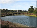
Pond in Bissoe Valley Nature Reserve
In the distance can be seen the remains of Point Mills Arsenic Refinery. Bissoe Valley Nature Reserve was donated to the Cornwall Wildlife Trust by Carrick District Council in 2000.
Image: © Rod Allday
Taken: 3 Oct 2008
0.16 miles