IMAGES TAKEN NEAR TO
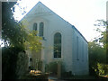
Salem, TRURO, TR4 8NA
Introduction
This page details the photographs taken nearby to Salem, TR4 8NA by members of the Geograph project.
The Geograph project started in 2005 with the aim of publishing, organising and preserving representative images for every square kilometre of Great Britain, Ireland and the Isle of Man.

There are currently over 7.5m images from over14,400 individuals and you can help contribute to the project by visiting https://www.geograph.org.uk
Image Map
Images are licensed for reuse under creativecommons.org/licenses/by-sa/2.0
Notes
- Clicking on the map will re-center to the selected point.
- The higher the marker number, the further away the image location is from the centre of the postcode.
Image Listing (19 Images Found)
Images are licensed for reuse under creativecommons.org/licenses/by-sa/2.0
Image
Details
Distance
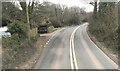
4
A Cornish Mining Walk
(Junction of a bridle path with the minor road between Wheal Busy and Todpool)
Image : Previous -- (10 of 34) -- Next : Image
I’ve included this photograph because one day some years ago I met another walker coming up from the path and, stopping to chat, he told me that the pole on the right of the picture had once been taller with a bridleway sign on it.
According to this person someone who objected to people using such routes had taken a grinder to this and a number of other poles in the area so as to remove the signs!
Continue southerly along the lane (right) in the direction of Todpool until you reach a road junction on the left.
---
Wheal is Cornish for Mine and this circular walk visits a number of mine ruins in the area between Chacewater and Scorrier. Buildings, chimneys and pits belonging to Wheal Busy, Unity Wood and Killifreth Engine House amongst others are visited.
Some of the walking is on minor roads and there is one major road to cross, so please take care.
Also, although there is an easy, safe footpath through Unity Wood, you should not leave the path except where marked.
The wood is private and there are a great many old mine workings whose safety should not be relied upon.
---
To go to the photograph for the start of the walk, click here Image
Image: © Alan Walker
Taken: 15 Jul 2007
0.18 miles
5
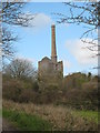
Hawkes Shaft Engine House Killifreth Mine
This has the tallest engine house stack in Cornwall
Image: © Rod Allday
Taken: 8 Apr 2008
0.20 miles
6
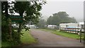
A Cornish Mining Walk
(The entrance to Chacewater Caravan Park)
Image : Previous -- (13 of 34) -- Next : Image
Continue left to right passed the entrance to this caravan park.
See also, this web site for Chacewater Caravan Park, http://www.chacewaterpark.co.uk/ .
---
Wheal is Cornish for Mine and this circular walk visits a number of mine ruins in the area between Chacewater and Scorrier. Buildings, chimneys and pits belonging to Wheal Busy, Unity Wood and Killifreth Engine House amongst others are visited.
Some of the walking is on minor roads and there is one major road to cross, so please take care.
Also, although there is an easy, safe footpath through Unity Wood, you should not leave the path except where marked.
The wood is private and there are a great many old mine workings whose safety should not be relied upon.
---
To go to the photograph for the start of the walk, click here Image
Image: © Alan Walker
Taken: 15 Jul 2007
0.20 miles
7

Killifreth Mine - calciner chimney
A free standing chimney near the stamps engine house. The chimney probably dates from about 1890 and is on the end of the labyrinth flue from the calciner.
Image: © Chris Allen
Taken: 14 May 2018
0.21 miles
8
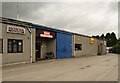
Commercial units, Cox Hill
A set of business units past which bridleway 301/13/2 runs to join the road to Chacewater.
Image: © Derek Harper
Taken: 18 May 2009
0.21 miles
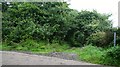
9
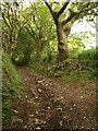
Bridleway near Cox Hill
Bridleway 301/49/1 at a sharp bend on its way from Cox Hill to the junction from which Image was taken.
Image: © Derek Harper
Taken: 18 May 2009
0.21 miles
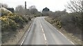
10
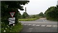
A Cornish Mining Walk
(Minor road crossing the Chacewater to Scorrier Road)
Image : Previous -- (9 of 34) -- Next : Image
Be careful crossing this main road. The speed limit is 40mph but on the day I took this photograph there were some who clearly hadn’t learnt to read big numbers.
Continue southerly, passing two more chimneys, along the lane in the direction of Todpool.
---
Wheal is Cornish for Mine and this circular walk visits a number of mine ruins in the area between Chacewater and Scorrier. Buildings, chimneys and pits belonging to Wheal Busy, Unity Wood and Killifreth Engine House amongst others are visited.
Some of the walking is on minor roads and there is one major road to cross, so please take care.
Also, although there is an easy, safe footpath through Unity Wood, you should not leave the path except where marked.
The wood is private and there are a great many old mine workings whose safety should not be relied upon.
---
To go to the photograph for the start of the walk, click here Image
Image: © Alan Walker
Taken: 15 Jul 2007
0.22 miles