IMAGES TAKEN NEAR TO
Cusveorth Coombe, TRURO, TR4 8LD
Introduction
This page details the photographs taken nearby to Cusveorth Coombe, TR4 8LD by members of the Geograph project.
The Geograph project started in 2005 with the aim of publishing, organising and preserving representative images for every square kilometre of Great Britain, Ireland and the Isle of Man.

There are currently over 7.5m images from over14,400 individuals and you can help contribute to the project by visiting https://www.geograph.org.uk
Image Map
Images are licensed for reuse under creativecommons.org/licenses/by-sa/2.0
Notes
- Clicking on the map will re-center to the selected point.
- The higher the marker number, the further away the image location is from the centre of the postcode.
Image Listing (5 Images Found)
Images are licensed for reuse under creativecommons.org/licenses/by-sa/2.0
Image
Details
Distance
2
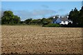
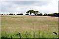
Farmland, Kea
A house in the hamlet of Cusveorth Coombe stands beside a recently cultivated field.
Image: © Andrew Smith
Taken: 7 May 2022
0.16 miles
4
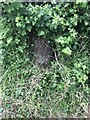
Old Boundary Marker near Cross Lanes, Kea parish
Mine Boundary Marker on the northwest side of a minor road northeast of Cross Lanes. Kea parish. An inscription of W M / M was observed, but W WJ / M 1 recorded by Historic England. Historic England have this recorded as a tin boundary stone. Once numerous, these stones originally marked the boundaries between mineral rights claims. Grade II Listed details https://historicengland.org.uk/listing/the-list/list-entry/1311013.
Milestone Society National ID: CW_KEA03em
Image: © P Barnett
Taken: 7 Jun 2024
0.18 miles