IMAGES TAKEN NEAR TO
Mount Hawke, TRURO, TR4 8DL
Introduction
This page details the photographs taken nearby to TR4 8DL by members of the Geograph project.
The Geograph project started in 2005 with the aim of publishing, organising and preserving representative images for every square kilometre of Great Britain, Ireland and the Isle of Man.

There are currently over 7.5m images from over14,400 individuals and you can help contribute to the project by visiting https://www.geograph.org.uk
Image Map
Images are licensed for reuse under creativecommons.org/licenses/by-sa/2.0
Notes
- Clicking on the map will re-center to the selected point.
- The higher the marker number, the further away the image location is from the centre of the postcode.
Image Listing (14 Images Found)
Images are licensed for reuse under creativecommons.org/licenses/by-sa/2.0
Image
Details
Distance
1
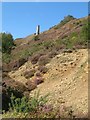
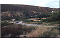
Spoil and chimney
A chimney associated with the Tywarnhale Mine, which spread along the south side of the valley. Although the derelict land is a terrible affliction, the colours of the ochrous spoil and the colonising heath are wonderful on such a day.
Image: © Jonathan Wilkins
Taken: 13 Sep 2019
0.18 miles
2
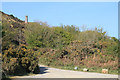
Chimney, Porthtowan Valley
This apparently isolated chimney is behind some houses on a bridleway and is in the vicinity of Tywarnhayle Mine but not necessarily connected.
Image: © Chris Allen
Taken: 25 Apr 2011
0.18 miles
3
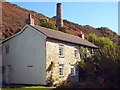
Dwelling Near Tywarnhayle Mine
The chimney in the background was associated with the crusher house of the mine. I'm not sure if the house was also associated with the mine.
Image: © Chris Andrews
Taken: 19 Jul 2016
0.19 miles
4
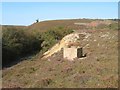
Capped shaft and spoil
Mining remains above the road at Come to Good.
Image: © Jonathan Wilkins
Taken: 13 Sep 2019
0.19 miles
5
Tywarnhayle mine, near Porthtowan
This disused mine and its extensive spoil tip is on the north valley side, about 1km south east of Porthtowan. View taken 1979
Image: © Crispin Purdye
Taken: Unknown
0.22 miles
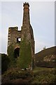
6
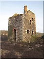
Engine house at Wheal Ellen mine
This engine house has an unusual castellated top to the chimney. More information about Wheal Ellen here: http://www.cornwall-calling.co.uk/mines/st-agnes/wheal-ellen.htm.
Image: © Rod Allday
Taken: 10 Mar 2009
0.23 miles
7
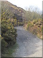
Footpath leading to Mount Hawke from Tywarnhayle Mine
Image: © Rod Allday
Taken: 10 Mar 2009
0.23 miles
8
Wheal Ellen
This engine house is on the site of Wheal Ellen (1834-1862) and was built in 1866 to house a 70 inch pumping engine but the venture failed before it was ever installed. The castellated chimney is unusual if not unique in Cornwall.
Image: © Chris Allen
Taken: 25 Apr 2011
0.23 miles
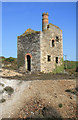
9
Wheal Ellen Mine
Wheal Ellen Mine dates from the mid 18th century and is situated a mile or so inland from Porth Towan.
Image: © Philip Halling
Taken: 31 Dec 2014
0.23 miles
10
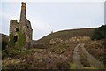
Wheal Ellen Mine
Wheal Ellen Mine dates from the mid 18th century and is about a mile or so inland from Porth Towan.
Image: © Philip Halling
Taken: 31 Dec 2014
0.23 miles