IMAGES TAKEN NEAR TO
Chapel Hill, TRURO, TR4 8AS
Introduction
This page details the photographs taken nearby to Chapel Hill, TR4 8AS by members of the Geograph project.
The Geograph project started in 2005 with the aim of publishing, organising and preserving representative images for every square kilometre of Great Britain, Ireland and the Isle of Man.

There are currently over 7.5m images from over14,400 individuals and you can help contribute to the project by visiting https://www.geograph.org.uk
Image Map
Images are licensed for reuse under creativecommons.org/licenses/by-sa/2.0
Notes
- Clicking on the map will re-center to the selected point.
- The higher the marker number, the further away the image location is from the centre of the postcode.
Image Listing (10 Images Found)
Images are licensed for reuse under creativecommons.org/licenses/by-sa/2.0
Image
Details
Distance
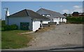
1
New houses at Porthtowan
The same ones as in Tony Atkin's photo Image but now completed.
Image: © Rod Allday
Taken: 9 May 2010
0.05 miles
2
Chapel on the Hill (Porthtowan Methodist)
Image: © Paul Barnett
Taken: 1 Jan 2022
0.06 miles
3
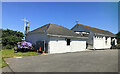
The Chapel on the Hill
As the name suggests, Porthtowan's active methodist church is situated on the plateau land at the head of a steep valley to the southwest of the village and high above it.
Image: © Tony Atkin
Taken: 15 Jun 2006
0.08 miles
4
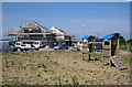
New Houses on the Outskirts of Porthtowan
The children's play castle on the right is probably associated with some already completed and occupied houses out of shot to the left.
Image: © Tony Atkin
Taken: 15 Jun 2006
0.10 miles
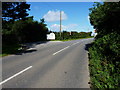
5
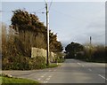
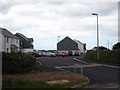
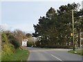
Staggered road junction, Chapel Hill, Porthtowan
Image: © David Smith
Taken: 11 Mar 2016
0.15 miles
6
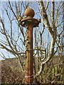
Old Direction Sign - Signpost near Nancekuke, Portreath parish
Ball finial - no arms; by the UC road, in parish of Portreath (Kerrier District), Nancekuke, North side of road junction.
Cornwall & Scilly HER.
HER Number: MCO56965 https://www.heritagegateway.org.uk/Gateway/Results_Single.aspx?uid=MCO56965&resourceID=1020
To be surveyed
Milestone Society National ID: CW_SW6946
Image: © Milestone Society
Taken: Unknown
0.15 miles
7
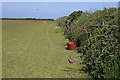
Paddock near Porthtowan
This field on the outskirts of Porthtowan is used for grazing horses, although there were no horses in evidence at the time I passed.
Image: © Tony Atkin
Taken: 15 Jun 2006
0.19 miles
8
Entrance to the Porthtowan Tourist Park
A caravan and campsite facility just south of Porthtowan.
Image: © Richard Law
Taken: 18 Sep 2012
0.20 miles
9
Sign and entrance for holiday park, Porthtowan
The line of trees on the right screen the camp from the road (and vice versa)
Image: © David Smith
Taken: 11 Mar 2016
0.21 miles
10
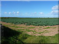
A field of greens near Porthtowan
Arable crops growing on the hills above Porthtowan village.
Image: © Richard Law
Taken: 18 Sep 2012
0.24 miles