IMAGES TAKEN NEAR TO
Trencrom, HAYLE, TR27 6NP
Introduction
This page details the photographs taken nearby to Trencrom, TR27 6NP by members of the Geograph project.
The Geograph project started in 2005 with the aim of publishing, organising and preserving representative images for every square kilometre of Great Britain, Ireland and the Isle of Man.

There are currently over 7.5m images from over14,400 individuals and you can help contribute to the project by visiting https://www.geograph.org.uk
Image Map
Images are licensed for reuse under creativecommons.org/licenses/by-sa/2.0
Notes
- Clicking on the map will re-center to the selected point.
- The higher the marker number, the further away the image location is from the centre of the postcode.
Image Listing (23 Images Found)
Images are licensed for reuse under creativecommons.org/licenses/by-sa/2.0
Image
Details
Distance
1
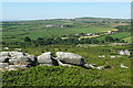
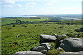
View from Trencrom Hill - south-west
Trencrom Hill is a modest granite summit, 200 metres, but it stands alone near the narrowest part of the Penwith peninsula so offers good views in all directions. It is easily climbed from a car park to the south, or why not walk St Michael's Way across the peninsula from Marazion to St Ives and climb Trencrom Hill on the way past? The land is owned by the National Trust. This view is south-west, towards Polpeor.
Image: © Graham Horn
Taken: 2 Jul 2011
0.04 miles
2
View from Trencrom Hill - south-east
Trencrom Hill is a modest granite summit, 200 metres, but it stands alone near the narrowest part of the Penwith peninsula so offers good views in all directions. It is easily climbed from a car park to the south, or why not walk St Michael's Way across the peninsula from Marazion to St Ives and climb Trencrom Hill on the way past? The land is owned by the National Trust. This view is south-east, towards the main summit, with a good view of St Michael's Mount Image on the south coast beyond.
Image: © Graham Horn
Taken: 2 Jul 2011
0.08 miles
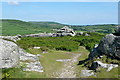
3
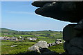
View from Trencrom Hill - north-west
Trencrom Hill is a modest granite summit, 200 metres, but it stands alone near the narrowest part of the Penwith peninsula so offers good views in all directions. It is easily climbed from a car park to the south, or why not walk St Michael's Way across the peninsula from Marazion to St Ives and climb Trencrom Hill on the way past? The land is owned by the National Trust. This view is north-west, towards the farm of the same name. Beyond are, left, Trink Hill Image and, centre, Trendrine Hill Image
Image: © Graham Horn
Taken: 2 Jul 2011
0.09 miles
4
View from Trencrom Hill - north-west
Trencrom Hill is a modest granite summit, 200 metres, but it stands alone near the narrowest part of the Penwith peninsula so offers good views in all directions. It is easily climbed from a car park to the south, or why not walk St Michael's Way across the peninsula from Marazion to St Ives and climb Trencrom Hill on the way past? The land is owned by the National Trust. This view is north-west, towards the farm of the same name.
Image: © Graham Horn
Taken: 2 Jul 2011
0.09 miles
5
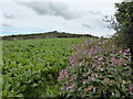
Kale field below Trencrom Hill
With a clump of Himalayan Balsam in the foreground.
Image: © David Medcalf
Taken: 7 Sep 2013
0.12 miles
6
Trencrom Hill
Farmland gives way to moorland on this granite hilltop.
Image: © Tony Atkin
Taken: 28 Aug 2007
0.12 miles
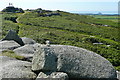
7
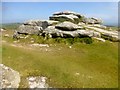
Trencrom Hill
Climbed up tor from car park to the south.
Name: Trencrom Hill
Hill number: 17615
Height: 176m / 577ft
Parent (Ma/M): 2887 Watch Croft [White Downs]
Section: 40: Cornwall & Devon
County/UA: Cornwall (CoU)
Class: Tump (100-199m)
Grid ref: SW 51807 36230
Summit feature: rock tor
Drop: 47m
Col: 129m SW513364
Image: © Rude Health
Taken: 6 May 2015
0.13 miles
8
View from Trencrom Hill - north-east
Trencrom Hill is a modest granite summit, 200 metres, but it stands alone near the narrowest part of the Penwith peninsula so offers good views in all directions. It is easily climbed from a car park to the south, or why not walk St Michael's Way across the peninsula from Marazion to St Ives and climb Trencrom Hill on the way past? The land is owned by the National Trust. This view is north-east, towards Hayle Estuary and St Ives Bay.
Image: © Graham Horn
Taken: 2 Jul 2011
0.14 miles
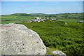
9
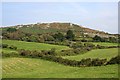
Trencrom
The farm below the hill of the same name. There is rich arable land in this central part of the Penwith peninsula. The hill is a granite carn, with plenty of overhanging rocks as seen here.
Image: © Graham Horn
Taken: 2 Jul 2011
0.16 miles
10
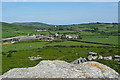
Trencrom
The farm below the hill of the same name. There is rich arable land in this central part of the Penwith peninsula.
Image: © Graham Horn
Taken: 2 Jul 2011
0.16 miles