IMAGES TAKEN NEAR TO
Leedstown, HAYLE, TR27 6BL
Introduction
This page details the photographs taken nearby to TR27 6BL by members of the Geograph project.
The Geograph project started in 2005 with the aim of publishing, organising and preserving representative images for every square kilometre of Great Britain, Ireland and the Isle of Man.

There are currently over 7.5m images from over14,400 individuals and you can help contribute to the project by visiting https://www.geograph.org.uk
Image Map
Images are licensed for reuse under creativecommons.org/licenses/by-sa/2.0
Notes
- Clicking on the map will re-center to the selected point.
- The higher the marker number, the further away the image location is from the centre of the postcode.
Image Listing (7 Images Found)
Images are licensed for reuse under creativecommons.org/licenses/by-sa/2.0
Image
Details
Distance
1
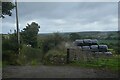
Crowan : Track
A track heads off the B3302 to Sunny Corner.
Image: © Lewis Clarke
Taken: 29 Sep 2022
0.11 miles
2
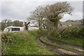
Approaching Binnerton Manor
Polytunnels and farm outbuildings at Binnerton Manor.
Image: © Elizabeth Scott
Taken: 8 Mar 2012
0.12 miles
4
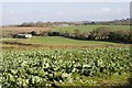
View across farmland near Paul's Green
Taken from a field entrance along the B3280 (in square SW5933) looking south east. The distant farm buildings in the middle of the picture are at Binnerton Manor. The middle-distance farm building on the left of the picture is at Paul's Green Farm.
Image: © Elizabeth Scott
Taken: 3 Mar 2012
0.16 miles
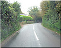
5

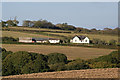
House and outbuildings at Sunny Corner
Taken from the main road, looking down the field and using a focal length in the middle of my zoom. Sadly, it was not sunny.
Image: © Elizabeth Scott
Taken: 1 Mar 2012
0.19 miles
6
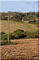
Lower Binnerton Farm
Viewed from near Gwedna. The River Hayle runs through the wooded dip in the centre of the photo.
Image: © Ian Capper
Taken: 28 Oct 2011
0.24 miles
7
Lower Binnerton Farm
Part of Lower Binnerton Farm, viewed from near Gwedna. The River Hayle runs through the wooded dip in the centre of the photo.
Image: © Ian Capper
Taken: 28 Oct 2011
0.25 miles