IMAGES TAKEN NEAR TO
Bosence Road, HAYLE, TR27 6AN
Introduction
This page details the photographs taken nearby to Bosence Road, TR27 6AN by members of the Geograph project.
The Geograph project started in 2005 with the aim of publishing, organising and preserving representative images for every square kilometre of Great Britain, Ireland and the Isle of Man.

There are currently over 7.5m images from over14,400 individuals and you can help contribute to the project by visiting https://www.geograph.org.uk
Image Map
Images are licensed for reuse under creativecommons.org/licenses/by-sa/2.0
Notes
- Clicking on the map will re-center to the selected point.
- The higher the marker number, the further away the image location is from the centre of the postcode.
Image Listing (7 Images Found)
Images are licensed for reuse under creativecommons.org/licenses/by-sa/2.0
Image
Details
Distance
1
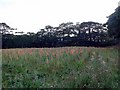
Field of Gladioli, Townshend
A field on the south side of Bosence Road (B3280) from Townshend to Relubbus.
Image: © Rich Tea
Taken: 31 Jul 2006
0.04 miles
2
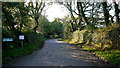
Bosence farm
A 'Rehab' centre deep in the West Cornwall countryside.
A footpath leads along the drive from the B3280.
See http://www.bosencefarm.co.uk/
Image: © Jonathan Billinger
Taken: 4 Oct 2013
0.04 miles
3
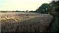
Unharvested field at Bosence
It's getting very late this year; perhaps it is meant for wildlife cover?
Image: © Jonathan Billinger
Taken: 4 Oct 2013
0.10 miles
4
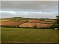
Field by Bosence Road and Godolphin Hill, dusk
Looking south-east from the field gate, towards Godolphin Hill (SW592312)
Image: © Rich Tea
Taken: 31 Jul 2006
0.17 miles
5
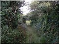
Overgrown lane from Bosence Road to Wheal Gilbert
Just after I had come into this lane and disturbed a buzzard flying along towards me at head height, a surprise for me and the buzzard.
Image: © Rich Tea
Taken: 31 Jul 2006
0.18 miles
6
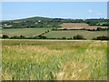
Field of barley at Bosence Farm
Looking towards Godolphin Hill.
Image: © Rod Allday
Taken: 13 Jul 2018
0.21 miles
7
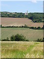
Fields off Bosence Road
The engine house is Image on the side of Godolphin Hill.
Image: © Rod Allday
Taken: 13 Jul 2018
0.22 miles