IMAGES TAKEN NEAR TO
Polmenor Downs, HAYLE, TR27 5JH
Introduction
This page details the photographs taken nearby to Polmenor Downs, TR27 5JH by members of the Geograph project.
The Geograph project started in 2005 with the aim of publishing, organising and preserving representative images for every square kilometre of Great Britain, Ireland and the Isle of Man.

There are currently over 7.5m images from over14,400 individuals and you can help contribute to the project by visiting https://www.geograph.org.uk
Image Map
Images are licensed for reuse under creativecommons.org/licenses/by-sa/2.0
Notes
- Clicking on the map will re-center to the selected point.
- The higher the marker number, the further away the image location is from the centre of the postcode.
Image Listing (23 Images Found)
Images are licensed for reuse under creativecommons.org/licenses/by-sa/2.0
Image
Details
Distance
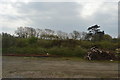
4
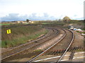
The Penzance-Paddington main line at Gwinear Road
Looking up the line from the level crossing. The tracks curve sharply here where the Helston branch line used to join from the right of the photo.
Image: © Rod Allday
Taken: 18 Nov 2012
0.05 miles
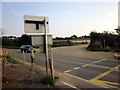
7

Level crossing on Gwinear Road south of Connor Downs
Image: © nick macneill
Taken: 4 Apr 2011
0.08 miles
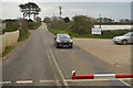
10
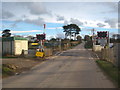
The level crossing at Gwinear Road
There used to be a station here, the remains of which to the right of the photo are still visible Image
Image: © Rod Allday
Taken: 18 Nov 2012
0.09 miles