IMAGES TAKEN NEAR TO
Trevaskis Meadow, HAYLE, TR27 5FL
Introduction
This page details the photographs taken nearby to Trevaskis Meadow, TR27 5FL by members of the Geograph project.
The Geograph project started in 2005 with the aim of publishing, organising and preserving representative images for every square kilometre of Great Britain, Ireland and the Isle of Man.

There are currently over 7.5m images from over14,400 individuals and you can help contribute to the project by visiting https://www.geograph.org.uk
Image Map
Images are licensed for reuse under creativecommons.org/licenses/by-sa/2.0
Notes
- Clicking on the map will re-center to the selected point.
- The higher the marker number, the further away the image location is from the centre of the postcode.
Image Listing (18 Images Found)
Images are licensed for reuse under creativecommons.org/licenses/by-sa/2.0
Image
Details
Distance
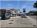
2
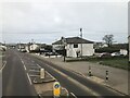
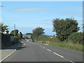
Connor Downs
The main street through Connor Downs was part of the old A30 to Penzance.
Image: © David Purchase
Taken: 9 Apr 2013
0.07 miles
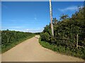
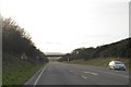
4
The Byway Open to All Traffic crosses the A30
Image: © David Medcalf
Taken: 8 Sep 2019
0.15 miles
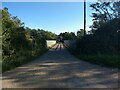
5
Footpath bridge over A30 north of Connor Downs
Image: © David Smith
Taken: 11 Mar 2016
0.15 miles
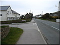
6
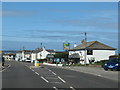
Turnpike Road Connor Downs at the Turnpike Inn
Image: © Roy Hughes
Taken: 10 Sep 2020
0.15 miles
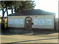
8
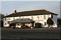
The Turnpike Inn, Connor Downs
The village of Connor Downs became established in the late 1800s. This shot shows the Turnpike Inn, a St. Austell Brewery pub.
Image: © Elizabeth Scott
Taken: 31 Dec 2008
0.16 miles