IMAGES TAKEN NEAR TO
Connor Hill, HAYLE, TR27 5DW
Introduction
This page details the photographs taken nearby to Connor Hill, TR27 5DW by members of the Geograph project.
The Geograph project started in 2005 with the aim of publishing, organising and preserving representative images for every square kilometre of Great Britain, Ireland and the Isle of Man.

There are currently over 7.5m images from over14,400 individuals and you can help contribute to the project by visiting https://www.geograph.org.uk
Image Map
Images are licensed for reuse under creativecommons.org/licenses/by-sa/2.0
Notes
- Clicking on the map will re-center to the selected point.
- The higher the marker number, the further away the image location is from the centre of the postcode.
Image Listing (21 Images Found)
Images are licensed for reuse under creativecommons.org/licenses/by-sa/2.0
Image
Details
Distance
1
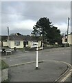
Direction Sign – Signpost on Connor Hill in Connor Downs
Located in Connor Downs on the northwest side of the junction of Connor Hill and Mutton Hill in Gwinear Gwithian parish. 2 arms and pawn finial.
Milestone Society National ID: CW_SW5939
Image: © Paul Barnett
Taken: 19 Feb 2023
0.03 miles
2
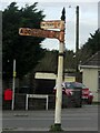
Direction Sign ? Signpost on Connor Hill in Connor Downs
Located in Connor Downs on the northwest side of the junction of Connor Hill and Mutton Hill in Gwinear Gwithian parish. 2 arms and pawn finial.
Milestone Society National ID: CW_SW5939
Image: © T Jenkinson
Taken: 15 Feb 2013
0.04 miles
3
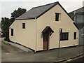
Tollhouse
Located in Connor Downs on the northeast side of the junction of Connor Hill and Mutton Hill in Gwinear Gwithian parish (Kerrier district).
Milestone Society National ID: CW.GWI
Image: © Paul Barnett
Taken: 22 Jan 2023
0.05 miles
4
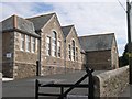
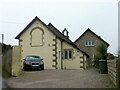
Connor Downs Primary School
A quite typical and well kept old school building which now houses the local Primary school.
Image: © Tony Atkin
Taken: 24 Sep 2005
0.08 miles
5
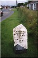
Old Milestone by Turnpike Road in Connor Downs
Carved stone post by the UC road (was A30), in parish of Gwinear Gwithian (Penwith District), Turnpike Road, Connor Downs village centre, by the road, on South side of road. Hayle facets, erected by the Hayle Bridge Causeway turnpike trust in the 19th century.
Inscription reads:-
HAYLE / 2 MILES / PENZANCE / 10 / LANDS END / 20 : : CAMBORNE / 4 MILES / REDRUTH / 7 / TRURO / 16
Grade II listed.
List Entry Number: 1409024
Milestone Society National ID: CW_PZCA10.
Image: © Paul Barnett
Taken: 5 Mar 2023
0.09 miles
7
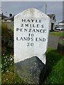
Old Milestone by Turnpike Road, Connor Downs
Carved stone post by the UC road (was A30), in parish of GWINEAR GWITHIAN (PENWITH District), Turnpike Road, Connor Downs village centre, by the road, on South side of road. Hayle facets, erected by the Hayle Bridge Causeway turnpike trust in the 19th century.
Inscription reads:-
: HAYLE / 2 MILES / PENZANCE / 10 / LANDS END / 20 : : CAMBORNE / 4 MILES / REDRUTH / 7 / TRURO / 16 :
Grade II listed.
List Entry Number: 1409024 https://historicengland.org.uk/listing/the-list/list-entry/1409024
Milestone Society National ID: CW_PZCA10.
Image: © Ian Thompson
Taken: Unknown
0.09 miles
8
Old Milestone by Turnpike Road in Connor Downs
Carved stone post by the UC road (was A30), in parish of GWINEAR GWITHIAN (PENWITH District), Turnpike Road, Connor Downs village centre, by the road, on South side of road. Hayle facets, erected by the Hayle Bridge Causeway turnpike trust in the 19th century.
Inscription reads:-
: HAYLE / 2 MILES / PENZANCE / 10 / LANDS END / 20 : : CAMBORNE / 4 MILES / REDRUTH / 7 / TRURO / 16 :
Grade II listed.
List Entry Number: 1409024 https://historicengland.org.uk/listing/the-list/list-entry/1409024
Milestone Society National ID: CW_PZCA10.
Image: © Rosy Hanns
Taken: 31 May 2019
0.09 miles
9
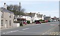
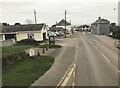
Connor Down
A village east of Hayle. The road through the village used to be the main road to Penzance before the building of the Hayle bypass. The village feels like it has not recovered from being split apart by a heavily used main road.
Image: © Tony Atkin
Taken: 24 Sep 2005
0.12 miles
10
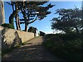
A fine wall and fine trees
Where the bridleway crosses Carwin Rise.
Image: © David Medcalf
Taken: 8 Sep 2019
0.13 miles