IMAGES TAKEN NEAR TO
Glebe Row, HAYLE, TR27 5AJ
Introduction
This page details the photographs taken nearby to Glebe Row, TR27 5AJ by members of the Geograph project.
The Geograph project started in 2005 with the aim of publishing, organising and preserving representative images for every square kilometre of Great Britain, Ireland and the Isle of Man.

There are currently over 7.5m images from over14,400 individuals and you can help contribute to the project by visiting https://www.geograph.org.uk
Image Map
Images are licensed for reuse under creativecommons.org/licenses/by-sa/2.0
Notes
- Clicking on the map will re-center to the selected point.
- The higher the marker number, the further away the image location is from the centre of the postcode.
Image Listing (62 Images Found)
Images are licensed for reuse under creativecommons.org/licenses/by-sa/2.0
Image
Details
Distance
2
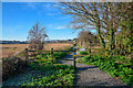
Phillack : Footpath
A footpath heading off Lethlean Lane.
Image: © Lewis Clarke
Taken: 2 Dec 2019
0.05 miles
3
Old Boundary Marker on Lethlean Lane, Hayle
Estate Boundary Marker outside the railing at the southwest end of a bridge on Lethlean Lane. HAYLE parish. Inscribed H / 1 and C C C / 1 on opposite faces. One of a series of stones put up by Harvey’s in 1867/8 marking out their waterfront holding acquired from the defunct Cornish Copper Company. Grade II Listed https://historicengland.org.uk/listing/the-list/list-entry/1160132. See also http://www.flickr.com/photos/bridgemarkertim/8488905085.
Milestone Society National ID: CW_HAY05em
Image: © R Hanns
Taken: 29 Aug 2019
0.05 miles
5
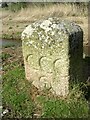
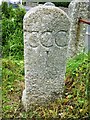
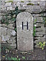
Old Boundary Marker close to Glebe Row, Hayle
Estate Boundary Marker beside a streamside footpath parallel to Glebe Row. Hayle parish. Inscribed CCC / 2 and H / 2 on opposite faces. One of a series of stones put up by Harvey’s in 1867/8 marking out their waterfront holding acquired from the defunct Cornish Copper Company.
Milestone Society National ID: CW_HAY02em
Image: © T Jenkinson
Taken: 17 Feb 2013
0.06 miles
6
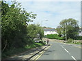
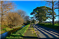
Phillack : Lethlean Lane
Looking along Lethlean Lane.
Image: © Lewis Clarke
Taken: 22 Oct 2019
0.06 miles
7
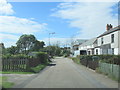
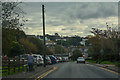
Phillack : Brookway
Looking along Brookway in Phillack.
Image: © Lewis Clarke
Taken: 2 Dec 2019
0.07 miles
8
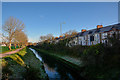
Hayle : Small Stream
A small stream seen from Leathlean Lane.
Image: © Lewis Clarke
Taken: 2 Dec 2019
0.14 miles

10
Old Boundary Marker on the King George V Memorial Walk in Hayle
Parish Boundary Marker set in a stone wall beside the King George V Memorial Walk. Hayle parish.
Milestone Society National ID: CW_HAY03pb
Image: © T Jenkinson
Taken: 15 Feb 2013
0.15 miles