IMAGES TAKEN NEAR TO
North Quay, TR27 4FW
Introduction
This page details the photographs taken nearby to North Quay, TR27 4FW by members of the Geograph project.
The Geograph project started in 2005 with the aim of publishing, organising and preserving representative images for every square kilometre of Great Britain, Ireland and the Isle of Man.

There are currently over 7.5m images from over14,400 individuals and you can help contribute to the project by visiting https://www.geograph.org.uk
Image Map
Images are licensed for reuse under creativecommons.org/licenses/by-sa/2.0
Notes
- Clicking on the map will re-center to the selected point.
- The higher the marker number, the further away the image location is from the centre of the postcode.
Image Listing (47 Images Found)
Images are licensed for reuse under creativecommons.org/licenses/by-sa/2.0
Image
Details
Distance
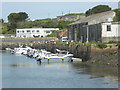
1
The harbour, Hayle
View WNW along the harbour towards the sea.
Image: © David P Howard
Taken: 13 Jan 2016
0.03 miles
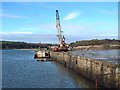
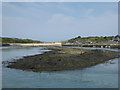
2
From the tip of South Quay into East Quay
Looking more or less northwards from the tip of the Grade II listed South Quay peninsula.
Image: © Richard Law
Taken: 26 Dec 2021
0.08 miles
3
Hayle old quay
The disused quay in Hayle Harbour.
Image: © Bob Jones
Taken: 31 Dec 2002
0.08 miles
5
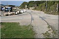
Rails from the Hayle Wharfs Branch Line
The rails embedded in the tarmac are from the Hayle Wharfs Branch Line which ran between the North Wharf and Hayle Station. It closed in 1979.
Image: © Tony Atkin
Taken: 6 Oct 2007
0.10 miles
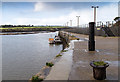
6
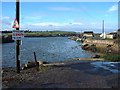
Hayle Harbour slipway
This slipway is at the eastern limit of the harbour, close to the harbour authority building.
Image: © Bob Jones
Taken: 30 Dec 2002
0.11 miles
7
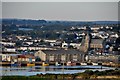
Hayle : Hayle Sea Front
Looking down from Lelant towards the buildings in the harbour area of Hayle.
Image: © Lewis Clarke
Taken: 2 Jul 2011
0.13 miles
8
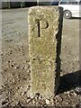
Old Boundary Marker on Hayle East Quay
Parish Boundary Marker on the quayside of Hayle East Quay. Hayle parish. Inscribed P and C on opposite faces, thought to be for Phillack and Copperhouse.
Milestone Society National ID: CW_PHCH01pb
Image: © T Jenkinson
Taken: 17 Feb 2013
0.13 miles
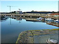
9
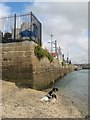
North Quay
The North Quay appears to be dedicated to fishing boats, judging from the tackle stored ashore.
Image: © Jonathan Wilkins
Taken: 12 Sep 2019
0.14 miles