IMAGES TAKEN NEAR TO
Hayle Terrace, HAYLE, TR27 4BS
Introduction
This page details the photographs taken nearby to Hayle Terrace, TR27 4BS by members of the Geograph project.
The Geograph project started in 2005 with the aim of publishing, organising and preserving representative images for every square kilometre of Great Britain, Ireland and the Isle of Man.

There are currently over 7.5m images from over14,400 individuals and you can help contribute to the project by visiting https://www.geograph.org.uk
Image Map
Images are licensed for reuse under creativecommons.org/licenses/by-sa/2.0
Notes
- Clicking on the map will re-center to the selected point.
- The higher the marker number, the further away the image location is from the centre of the postcode.
Image Listing (146 Images Found)
Images are licensed for reuse under creativecommons.org/licenses/by-sa/2.0
Image
Details
Distance
1
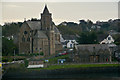
Phillack : St Elwyn
Looking from Phillack across to St Elwyn on the opposite side of Copperhouse Pool.
Image: © Lewis Clarke
Taken: 22 Oct 2019
0.02 miles
2
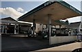
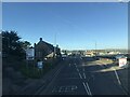
Hayle : BWOC Petrol Station
A petrol station on Hayle Terrace. The newspaper headline is about a new Hayle hospice.
Image: © Lewis Clarke
Taken: 3 Jul 2011
0.02 miles
3
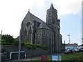
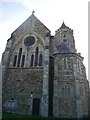
The Church of St Elwyn the Martyr at Hayle
Viewed from the north.
Image: © Peter Wood
Taken: 2 May 2017
0.03 miles
4
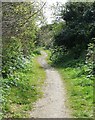
Lost line
Trackbed of the former Hayle Wharves branch line, now used as a footpath, although not a public right of way. This view looks towards the former junction with the mainline at Hayle viaduct.
Image: © Malcolm Kewn
Taken: 18 Apr 2008
0.03 miles
5
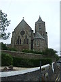
Hayle Church
The stubby spire used to have a weathervane which was an intersected trig station but the church still carries a flush bracket bench mark lower right. See http://www.geograph.org.uk/photo/5159950 for a close-up and http://www.bench-marks.org.uk/bm19661 for details.
Image: © Brian Westlake
Taken: 9 Oct 2016
0.03 miles
6
Flush Bracket OSBM S7036: Hayle, Church
The flush bracket on Hayle church. See http://www.geograph.org.uk/photo/5159946 for a wider view and http://www.bench-marks.org.uk/bm19661 for details.
Image: © Brian Westlake
Taken: 9 Oct 2016
0.03 miles
8
Hayle Terrace passing a former Sunday School
Image: © Paul Barnett
Taken: 5 Feb 2023
0.03 miles
9
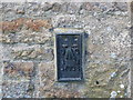
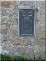
Ordnance Survey Flush Bracket S7036
This bracket can be found on the wall of St Elwyn's Church at Hayle. The benchmark height is recorded as being 8.292 metres above sea level.
For more detail see : http://www.bench-marks.org.uk/bm19661
Image: © Peter Wood
Taken: 2 May 2017
0.04 miles
10
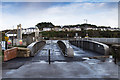
Railway swing bridge, Hayle
An old railway swing bridge which has been renovated and put into use as a pedestrian and cycleway bridge.
See an earlier image from six years ago before renovation. Image
Image: © David P Howard
Taken: 13 Jan 2016
0.04 miles