IMAGES TAKEN NEAR TO
Amalveor, ST. IVES, TR26 3AG
Introduction
This page details the photographs taken nearby to TR26 3AG by members of the Geograph project.
The Geograph project started in 2005 with the aim of publishing, organising and preserving representative images for every square kilometre of Great Britain, Ireland and the Isle of Man.

There are currently over 7.5m images from over14,400 individuals and you can help contribute to the project by visiting https://www.geograph.org.uk
Image Map
Images are licensed for reuse under creativecommons.org/licenses/by-sa/2.0
Notes
- Clicking on the map will re-center to the selected point.
- The higher the marker number, the further away the image location is from the centre of the postcode.
Image Listing (8 Images Found)
Images are licensed for reuse under creativecommons.org/licenses/by-sa/2.0
Image
Details
Distance
1
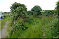
Pasture at Amalveor
There is an unusually large pasture here, before the land becomes open access land on the approach to Amalveor Downs.
Image: © Graham Horn
Taken: 6 Jul 2011
0.11 miles
2
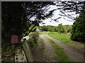
Bridleway at Embla Vean
The bridleway that leads to Amalveor Downs starts here to the right of the buildings. It is rather overgrown at the entrance but it improves.
Image: © Graham Horn
Taken: 6 Jul 2011
0.13 miles
4
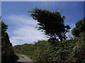
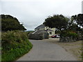
Hedge on way to Amalwhidden
The trees take the shape dictated by the winds from the sea.
Image: © Sheila Russell
Taken: 7 Aug 2005
0.14 miles
5
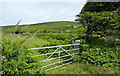
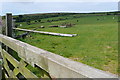
Gateway at Amalveor
This pasture is on the edge of open access land that leads towards Trendrine Hill Image seen on the horizon. However, access is difficult from this side.
Image: © Graham Horn
Taken: 6 Jul 2011
0.18 miles
6
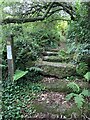
Stone Stile SW4837
It’s sited on the path east side of a small granite clapper bridge across the stream, on the footpath from Beagletodn, after the ponds leading towards the lane to Amalveor.
Coffen stile. It is 10 feet long, with horizontal treads and a suggestion of a pit under them. This stile is in good condition on a well-used path. It is 3 feet wide across the one slightly raised tread and 18” deep.
Public footpath 119/12/1 silver from Beagletodn to Amalveor
Image: © Sue Partington
Taken: 29 Jul 2021
0.22 miles
7
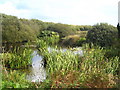
One of the ponds at Sweet Water Trout Farm
The farm operates as a B & B and guests may fish in the ponds, one stocked with trout and one with carp http://www.sweetwater-bb.com/index.html.
Image: © Rod Allday
Taken: 6 Oct 2010
0.23 miles