IMAGES TAKEN NEAR TO
ST. IVES, TR26 3AE
Introduction
This page details the photographs taken nearby to TR26 3AE by members of the Geograph project.
The Geograph project started in 2005 with the aim of publishing, organising and preserving representative images for every square kilometre of Great Britain, Ireland and the Isle of Man.

There are currently over 7.5m images from over14,400 individuals and you can help contribute to the project by visiting https://www.geograph.org.uk
Image Map
Images are licensed for reuse under creativecommons.org/licenses/by-sa/2.0
Notes
- Clicking on the map will re-center to the selected point.
- The higher the marker number, the further away the image location is from the centre of the postcode.
Image Listing (15 Images Found)
Images are licensed for reuse under creativecommons.org/licenses/by-sa/2.0
Image
Details
Distance
1
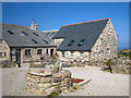
Cottages at Trowan
The hamlet of Trowan was derelict, apart from the farmhouse, until it was purchased by a property developer from Yorkshire in 2003. The dozen or so buildings have now been renovated as holiday accommodation
Image: © Rod Allday
Taken: 17 Apr 2010
0.02 miles
2
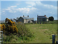
Trowan
A farmstead that seems to be converted into a settlement of several dwellings.
Image: © Robin Webster
Taken: 17 May 2013
0.02 miles
3
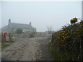
Trowan Farm
The terminus of Trowan Lane, complete with sea mist.
Image: © Jonathan Billinger
Taken: 2 Apr 2008
0.03 miles
4
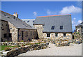
Trowan
Lots of recently converted farm buildings.
Image: © Pierre Terre
Taken: 20 Jul 2008
0.04 miles

6
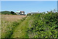
Towards Trowan
An inland path heads west from St Ives, linking many fields and interspersed with small farms. This is the first, Trowan, adjacent to a field of coarse grass.
Image: © Graham Horn
Taken: 3 Jul 2011
0.04 miles
7
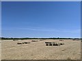
Hay bales awaiting pickup on inland path from St Ives towards Zennor on farm field
I love how these silent natural structures are awaiting their use!
Image: © The Golden Flea
Taken: 31 May 2020
0.07 miles
8
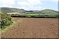
Field near Trowan
Looking towards Rosewall and Trevalgan hills from the footpath east of Trowan. The hills are part of the Land's End granite mass, dropping steeply to the coastal plateau of Devonian slates and volcanics.
Image: © Pierre Terre
Taken: 20 Jul 2008
0.08 miles
10
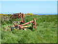
Footpath to Zennor
The St Ives to Zennor footpath heads towards Trowan.
Image: © Pierre Terre
Taken: 20 Jul 2008
0.12 miles