IMAGES TAKEN NEAR TO
Budhyn Mellyon, ST. IVES, TR26 2QZ
Introduction
This page details the photographs taken nearby to Budhyn Mellyon, TR26 2QZ by members of the Geograph project.
The Geograph project started in 2005 with the aim of publishing, organising and preserving representative images for every square kilometre of Great Britain, Ireland and the Isle of Man.

There are currently over 7.5m images from over14,400 individuals and you can help contribute to the project by visiting https://www.geograph.org.uk
Image Map
Images are licensed for reuse under creativecommons.org/licenses/by-sa/2.0
Notes
- Clicking on the map will re-center to the selected point.
- The higher the marker number, the further away the image location is from the centre of the postcode.
Image Listing (18 Images Found)
Images are licensed for reuse under creativecommons.org/licenses/by-sa/2.0
Image
Details
Distance
1
Boskerris Farmhouse, Carbis Bay
Built in the late 18th century of coursed and faced granite, Boskerris Farmhouse was Grade II listed https://britishlistedbuildings.co.uk/101143336-boskerris-farmhouse-st-ives#.YgUuS9_P3IU & https://historicengland.org.uk/listing/the-list/list-entry/1143336 in 1972.
Image: © Richard Law
Taken: 24 Dec 2021
0.14 miles
2
Boskerris Woollas house, Carbis Bay
A rear view of this fine house, built in the late 18th century, primarily of dressed granite blocks. It attracted a Grade II listing https://britishlistedbuildings.co.uk/101136949-boskerris-woollas-st-ives#.Yg1dGN_P3IU & https://historicengland.org.uk/listing/the-list/list-entry/1136949 in 1972.
Image: © Richard Law
Taken: 24 Dec 2021
0.15 miles
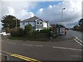
3
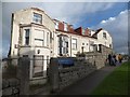
Former hotel, St Margaret's Hotel, Carbis Bay
A dilapidated building on St Ives Road, Carbis Bay
Image: © David Smith
Taken: 17 Jan 2014
0.18 miles
4
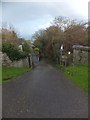
Footpath into Carbis Valley
This path leads to the coast close to the Carbis Bay railway viaduct Image
Image: © David Smith
Taken: 17 Jan 2014
0.19 miles
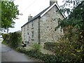
5
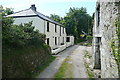
Farm at Carbis Water
The footpath towards Withen goes through the middle of this group of farm buildings.
Image: © Graham Horn
Taken: 2 Jul 2011
0.20 miles
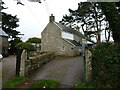
6
Footpath from Withen
The footpath has crossed the pastures of the farm, Withen, and here enters an enclosed grassy lane.
Image: © Graham Horn
Taken: 2 Jul 2011
0.20 miles
7
Boskerris Road, Carbis Bay
This road leads down the hill through a residential area to the railway station
Image: © David Smith
Taken: 17 Jan 2014
0.20 miles
8
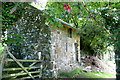
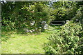
Barn at Carbis Water
There were some hibiscus fronds overhanging the path too.
Image: © Graham Horn
Taken: 2 Jul 2011
0.21 miles