IMAGES TAKEN NEAR TO
Wheal Speed, ST. IVES, TR26 2QW
Introduction
This page details the photographs taken nearby to Wheal Speed, TR26 2QW by members of the Geograph project.
The Geograph project started in 2005 with the aim of publishing, organising and preserving representative images for every square kilometre of Great Britain, Ireland and the Isle of Man.

There are currently over 7.5m images from over14,400 individuals and you can help contribute to the project by visiting https://www.geograph.org.uk
Image Map
Images are licensed for reuse under creativecommons.org/licenses/by-sa/2.0
Notes
- Clicking on the map will re-center to the selected point.
- The higher the marker number, the further away the image location is from the centre of the postcode.
Image Listing (23 Images Found)
Images are licensed for reuse under creativecommons.org/licenses/by-sa/2.0
Image
Details
Distance
1
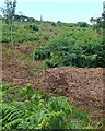
Towards Knill's Monument
There are many paths in this area, with bracken covered ground between. On top of the hill is Knill's Monument, and although there is no path visible here the monument is actually very accessible.
Image: © Graham Horn
Taken: 2 Jul 2011
0.08 miles
2
Danger mine shaft
A rather worrying sign, especially as it was hidden in thick bracken. Fortunately the path I am on was clear.
Image: © Graham Horn
Taken: 2 Jul 2011
0.08 miles
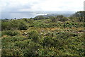
3
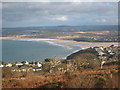
Heathland on Trelyon Downs
A high point overlooking St Ives Bay and the Hayle Estuary.
Image: © Rod Allday
Taken: 1 Dec 2012
0.10 miles
4
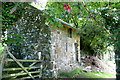
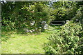
Barn at Carbis Water
There were some hibiscus fronds overhanging the path too.
Image: © Graham Horn
Taken: 2 Jul 2011
0.13 miles
5
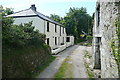
Farm at Carbis Water
The footpath towards Withen goes through the middle of this group of farm buildings.
Image: © Graham Horn
Taken: 2 Jul 2011
0.14 miles
6
Near Knill's Monument
Looking east towards St Ives Bay and Hayle Towans.
Image: © Pierre Terre
Taken: 25 Jul 2008
0.14 miles
7
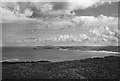
View from Knill's Monument, 1949
The family holiday diary entry reads: “. . . went on to Knill's Monument . . . Wonderful views again with sun and not so grey as night before – lighthouse on Trevose Head easy to pick out and also Perranporth.”
Trevose Head is 50 km distant, and not actually in the picture. The visible lighthouse is Godrevy, a mere 7.7 km away.
Image: © David M Murray-Rust
Taken: 1 Sep 1949
0.14 miles
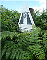
8
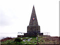
Knill's Monument
On a hill above St Ives, at 170m, with an excellent view of Carbis Bay to the east.
Image: © Sheila Russell
Taken: 18 Jan 2006
0.14 miles
9
Footpath from Withen
The footpath has crossed the pastures of the farm, Withen, and here enters an enclosed grassy lane.
Image: © Graham Horn
Taken: 2 Jul 2011
0.15 miles
10
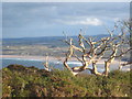
A dead tree amongst the heathland on Trelyon Downs
The downs have a commanding view across St Ives Bay.
Image: © Rod Allday
Taken: 1 Dec 2012
0.16 miles