IMAGES TAKEN NEAR TO
Talland Road, ST. IVES, TR26 2FF
Introduction
This page details the photographs taken nearby to Talland Road, TR26 2FF by members of the Geograph project.
The Geograph project started in 2005 with the aim of publishing, organising and preserving representative images for every square kilometre of Great Britain, Ireland and the Isle of Man.

There are currently over 7.5m images from over14,400 individuals and you can help contribute to the project by visiting https://www.geograph.org.uk
Image Map
Images are licensed for reuse under creativecommons.org/licenses/by-sa/2.0
Notes
- Clicking on the map will re-center to the selected point.
- The higher the marker number, the further away the image location is from the centre of the postcode.
Image Listing (345 Images Found)
Images are licensed for reuse under creativecommons.org/licenses/by-sa/2.0
Image
Details
Distance
2
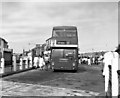
St. Ives bus station
This is a second-hand ex-London Transport 'DMS' class bus, preparing to work the long cross-county route 17 from St. Ives to Penzance.
Image: © Dr Neil Clifton
Taken: 22 Jul 1986
0.03 miles
3
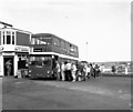
St. Ives bus station (2)
On this occasion, there was a large queue of people for the Penzance bus.
Image: © Dr Neil Clifton
Taken: 22 Jul 1986
0.03 miles
4
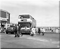
St. Ives Bus Station (3)
The Penzance bus had left, full and standing, but still some would-be passengers had been left behind, so a little improvisation had to be done. This 'Olympian' double-decker had just arrived off a long-distance service from Bristol, so a relief driver was found who would take it to Penzance for the benefit of those left waiting.
Image: © Dr Neil Clifton
Taken: 22 Jul 1986
0.03 miles
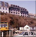
5
St Ives Bay Hotel
A Shearings Hotel. I was staying here for a 'Tinsel and Turkey' event - I enjoyed the food.
Image: © Chris Allen
Taken: 3 Nov 2013
0.04 miles
6
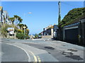
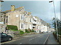
St Ives : Albert Road
A road in St Ives.
Image: © Lewis Clarke
Taken: 29 Sep 2022
0.04 miles
7
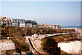
St Ives Porthminster Beach & Station April 1986
Image: © Roy Hughes
Taken: 16 Apr 1986
0.04 miles
8
St. Ives Railway Station and Carrack Widden Flats, February 1986
Image: © Roy Hughes
Taken: Unknown
0.04 miles
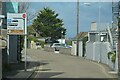
9
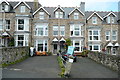
Guest Houses on Bellers Road
This road is quite steep, as seen by the rise of the roof lines. There was a sign on the post saying, to the effect, do not stand too close as this post has been knocked over and may fall at any time and we can't be held to be responsible.
Image: © Graham Horn
Taken: 6 Jul 2011
0.05 miles
10
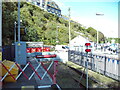
End of the line, St Ives railway station
A sand drag and buffer stop are positioned beyond the furthest point normally reached by trains, to protect the footpath into the car park from the possibility of a train overrunning. The car park on the right is on the site of the former railway station here; the current station is on the edge of what would have been the goods yard, a bit further from the town centre.
Image: © Richard Vince
Taken: 3 Oct 2023
0.05 miles