IMAGES TAKEN NEAR TO
Talland Road, ST. IVES, TR26 2FD
Introduction
This page details the photographs taken nearby to Talland Road, TR26 2FD by members of the Geograph project.
The Geograph project started in 2005 with the aim of publishing, organising and preserving representative images for every square kilometre of Great Britain, Ireland and the Isle of Man.

There are currently over 7.5m images from over14,400 individuals and you can help contribute to the project by visiting https://www.geograph.org.uk
Image Map
Images are licensed for reuse under creativecommons.org/licenses/by-sa/2.0
Notes
- Clicking on the map will re-center to the selected point.
- The higher the marker number, the further away the image location is from the centre of the postcode.
Image Listing (254 Images Found)
Images are licensed for reuse under creativecommons.org/licenses/by-sa/2.0
Image
Details
Distance
1
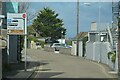
St Ives : Albert Road
A road in St Ives.
Image: © Lewis Clarke
Taken: 29 Sep 2022
0.02 miles
2
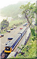
St. Ives station
The diesel unit is working on a service to St. Erth
Image: © Dr Neil Clifton
Taken: 25 May 1981
0.03 miles
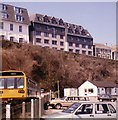
4
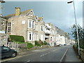
St Ives Bay Hotel
A Shearings Hotel. I was staying here for a 'Tinsel and Turkey' event - I enjoyed the food.
Image: © Chris Allen
Taken: 3 Nov 2013
0.04 miles
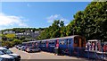
5
St Ives station, 1996
View southward, towards St Erth. Compare with Image], showing the original two-platform (island) station, which was replaced by this single-platform station, c. 200 yards further south in 5/71. Note the old Class 101 DMU.
Image: © Ben Brooksbank
Taken: 11 Jun 1996
0.05 miles
6
St. Ives Railway Station and Carrack Widden Flats, February 1986
Image: © Roy Hughes
Taken: Unknown
0.05 miles
7
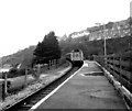
The end of the line, St Ives
Fourteen minutes after leaving St Erth, the train reaches St Ives. If the speed limit on the line were lowered, the pleasure would rise!
Image: © AlastairG
Taken: 3 Jul 2014
0.05 miles
8
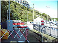
End of the line, St Ives railway station
A sand drag and buffer stop are positioned beyond the furthest point normally reached by trains, to protect the footpath into the car park from the possibility of a train overrunning. The car park on the right is on the site of the former railway station here; the current station is on the edge of what would have been the goods yard, a bit further from the town centre.
Image: © Richard Vince
Taken: 3 Oct 2023
0.06 miles
9
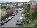
St. Ives railway station, Cornwall
Opened in 1877 by the Great Western Railway as the terminus from St. Erth on the Cornish main line, the main station platform used to be where the right-hand row of cars now is, with the tracks being where the left hand row of cars is. In 1971, British Rail shortened the line to end where the current station is, in the middle distance.
Image: © Nigel Thompson
Taken: 28 Apr 2012
0.06 miles
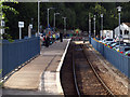
10
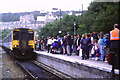
St. Ives Station
A diesel multiple unit train arriving at the branch line terminus at St. Ives.
During the week that this image was taken, a total solar eclipse occurred over the far south west of England. This attracted large numbers of visitors. The train operator ran longer trains than normal on some of its services in Devon and Cornwall, including the St. Ives branch line.
Image: © Malc McDonald
Taken: Unknown
0.06 miles