IMAGES TAKEN NEAR TO
Trerice Place, ST. IVES, TR26 1AT
Introduction
This page details the photographs taken nearby to Trerice Place, TR26 1AT by members of the Geograph project.
The Geograph project started in 2005 with the aim of publishing, organising and preserving representative images for every square kilometre of Great Britain, Ireland and the Isle of Man.

There are currently over 7.5m images from over14,400 individuals and you can help contribute to the project by visiting https://www.geograph.org.uk
Image Map
Images are licensed for reuse under creativecommons.org/licenses/by-sa/2.0
Notes
- Clicking on the map will re-center to the selected point.
- The higher the marker number, the further away the image location is from the centre of the postcode.
Image Listing (63 Images Found)
Images are licensed for reuse under creativecommons.org/licenses/by-sa/2.0
Image
Details
Distance
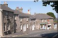
4
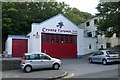
St Ives old fire station
St Ives old fire station, The Stennack, St Ives, Cornwall is now a carpet warehouse. It was replaced by Image
Image: © Kevin Hale
Taken: 8 Jul 2007
0.11 miles
6
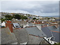
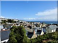
St Ives : Coastal Scenery
Looking down into St Ives with the church steeple and the sand beach in view.
Image: © Lewis Clarke
Taken: 2 Jul 2011
0.15 miles
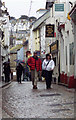
7
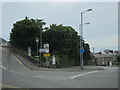
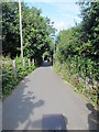
St Ives Higher Stennack Turn Left For Porthmeor Beach
Image: © Roy Hughes
Taken: 26 Jun 2016
0.15 miles
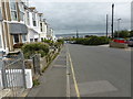
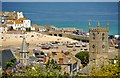
8
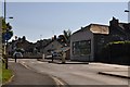
St Ives : Higher Stennack
A roundabout along Higher Stennack which leads out of St Ives.
Image: © Lewis Clarke
Taken: 2 Jul 2011
0.16 miles