IMAGES TAKEN NEAR TO
Veryan Green, TRURO, TR2 5QQ
Introduction
This page details the photographs taken nearby to TR2 5QQ by members of the Geograph project.
The Geograph project started in 2005 with the aim of publishing, organising and preserving representative images for every square kilometre of Great Britain, Ireland and the Isle of Man.

There are currently over 7.5m images from over14,400 individuals and you can help contribute to the project by visiting https://www.geograph.org.uk
Image Map
Images are licensed for reuse under creativecommons.org/licenses/by-sa/2.0
Notes
- Clicking on the map will re-center to the selected point.
- The higher the marker number, the further away the image location is from the centre of the postcode.
Image Listing (9 Images Found)
Images are licensed for reuse under creativecommons.org/licenses/by-sa/2.0
Image
Details
Distance
1
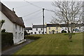
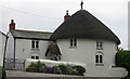
Cottages on Veryan Green
Looking north-east towards the row of cottages imaginatively called 'The Row'.
Image: © Simon Mortimer
Taken: 13 Apr 2019
0.04 miles
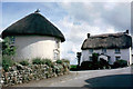
2
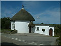
Veryan, One of the Round Houses
Folklore tells us that the Round Houses were built by a Vicar, in order that there were no corners for the Devil to hide in.
Image: © Neil Kennedy
Taken: 21 Aug 2004
0.06 miles
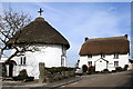
3
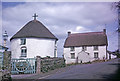
Round House, Veryan, Roseland, Cornwall taken 1964
Five of these round houses were built by the Trist Family in the early 19th Century and situated at the entrances to the village - these private thatched circular cottages have become a unique feature of Veryan. It was thought that the round shape would guard the village from evil as there were no corners in which the devil could hide!
Image: © Christine Matthews
Taken: Unknown
0.06 miles
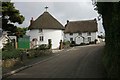
4
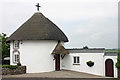
The Right Roundhouse, Veryan Green
Grade II* Listed round cottage. Probably built between 1815 and 1818, reputedly inspired by one in St Winnow. One of 5 round houses built (for about £42 each) in Veryan by Hugh Rowe, a Lostwithiel builder, for the Reverend Jeremiah Trist (1755-1829). Trist added the church clock tower and also had two schools and Parc Behan built (In 1870-72 John Marius Wilson says the church was rebuilt in 1848). Reportedly built for his five daughters, it seems they were lived in by his tenants or labourers of the village. Trist had five daughters and two sons but by 1815 Louisa had died and Maria died in 1818.
Image: © Jo and Steve Turner
Taken: 11 Jun 2005
0.06 miles
5
The Left Roundhouse, Veryan Green
Grade II* Listed round cottage. Probably built between 1815 and 1818, reputedly inspired by one in St Winnow. One of 5 round houses built (for about £42 each) in Veryan by Hugh Rowe, a Lostwithiel builder, for the Reverend Jeremiah Trist (1755-1829). Trist added the church clock tower and also had two schools and Parc Behan built (In 1870-72 John Marius Wilson says the church was rebuilt in 1848). Reportedly built for his five daughters, it seems they were lived in by his tenants or labourers of the village. Trist had five daughters and two sons but by 1815 Louisa had died and Maria died in 1818. September 2019, application was approved to make a ground floor bedroom with shower/wash-room facilities.
Image: © Jo and Steve Turner
Taken: 11 Jun 2005
0.07 miles
7
Round House Veryan Green (2010)
One of the five round houses in Veryan built early 19th century by Hugh Rowe of Lostwithiel (Pevsner).
Image: © Fred James
Taken: 16 Mar 2010
0.07 miles
8
Attractive thatch houses at Veryan
A very unspoilt village on the Roseland part of Cornwall. These houses were built by the Trist Family in the early 19th Century and situated at the entrances to the village - these private thatched circular cottages have become a unique feature of Veryan.It was thought that the round shape would guard the village from evil as there were no corners in which the devil could hide.
Image: © roger geach
Taken: 24 Sep 2010
0.09 miles
9
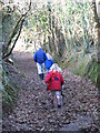
Sunken Cornish lane near Veryan Green
Sunken Cornish lane leading down through farm land to woods near the village of Veryan Green. Part of the right of way network in the area.
Image: © Helen Taylor
Taken: 2 Jan 2006
0.23 miles