IMAGES TAKEN NEAR TO
St. Just In Roseland, TRURO, TR2 5JJ
Introduction
This page details the photographs taken nearby to TR2 5JJ by members of the Geograph project.
The Geograph project started in 2005 with the aim of publishing, organising and preserving representative images for every square kilometre of Great Britain, Ireland and the Isle of Man.

There are currently over 7.5m images from over14,400 individuals and you can help contribute to the project by visiting https://www.geograph.org.uk
Image Map
Images are licensed for reuse under creativecommons.org/licenses/by-sa/2.0
Notes
- Clicking on the map will re-center to the selected point.
- The higher the marker number, the further away the image location is from the centre of the postcode.
Image Listing (2 Images Found)
Images are licensed for reuse under creativecommons.org/licenses/by-sa/2.0
Image
Details
Distance
1
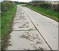
Commerans Farm Lane, St Just in Roseland
The road was built by a local contractor during WWII to provide access to the Turnaware Point embarkation jetties code named "Dolphins".
The left hand section shows a scheme to widen the road, carried out by the US Army Corps of Transportation, to ease traffic jams .
Local sources point out that the Americans used inferior concrete composed mainly of large hardcore. Certainly the Cornish version has better stood the test of time.
Image: © Rabbi WP Thinrod
Taken: 24 Apr 2008
0.02 miles
2
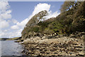
Fal Estuary, St Just in Roseland
At low tide several small beaches are exposed on the Eastern side of the Fal Estuary. In the background is Turnaware Point at the start of the "river" proper.
In fact the estuary is a drowned valley or "ria" and the rivers that feed it, the Fal, Allen and Carnon, are relatively insignificant. The overwhelming flow of water is saline and tidal.
Image: © Rabbi WP Thinrod
Taken: 23 Apr 2008
0.20 miles