IMAGES TAKEN NEAR TO
Tybesta, TRURO, TR2 4ST
Introduction
This page details the photographs taken nearby to Tybesta, TR2 4ST by members of the Geograph project.
The Geograph project started in 2005 with the aim of publishing, organising and preserving representative images for every square kilometre of Great Britain, Ireland and the Isle of Man.

There are currently over 7.5m images from over14,400 individuals and you can help contribute to the project by visiting https://www.geograph.org.uk
Image Map
Images are licensed for reuse under creativecommons.org/licenses/by-sa/2.0
Notes
- Clicking on the map will re-center to the selected point.
- The higher the marker number, the further away the image location is from the centre of the postcode.
Image Listing (44 Images Found)
Images are licensed for reuse under creativecommons.org/licenses/by-sa/2.0
Image
Details
Distance

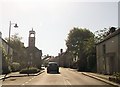
2
North Grampound
A photo from the unclassified road between Grampound and Grampound Road looking back at the east side of the village on the hill towards St Austell. The houses are on Mill Lane.
Image: © Mike Lyne
Taken: 11 Apr 2020
0.05 miles
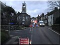
3
Pepo Lane in Grampound
Looking westward from St Nuns Church
Image: © Peter Wood
Taken: 5 May 2017
0.08 miles
4
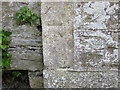
Ordnance Survey Cut Mark
This mark can be found on the roadside wall of St Nun's Church in Grampound. The benchmark height is recorded as being 33.324 metres above sea level.
For more detail see : http://www.bench-marks.org.uk/bm85772
Image: © Peter Wood
Taken: 5 May 2017
0.10 miles
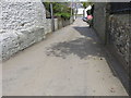
5

East side of Grampound
A photo from the unclassified road between Grampound and Grampound Road looking back at the east side of the village on the hill towards St Austell.
Image: © Mike Lyne
Taken: 11 Apr 2020
0.10 miles
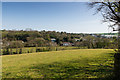
6
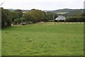
Outside Grampound
On the hillside just to the north of Grampound village.
Image: © Tony Atkin
Taken: 26 Aug 2006
0.10 miles
7
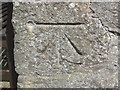
Ordnance Survey Cut Mark with Bolt
This can be found on the Wall of The Market House in Grampound. The benchmark height is recorded as being 33.9922 metres above sea level.
For more detail see : http://www.bench-marks.org.uk/bm45662
Image: © Peter Wood
Taken: 5 May 2017
0.11 miles
8
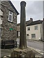
Old Central Cross on the A390 Fore Street in Grampound
Grampound Market Cross, the old shaft, base and steps of a central cross. Set on the northeast side of the T junction of the A390 Fore Street and Pepo Lane in Grampound with Creed parish. Grade II Listed https://historicengland.org.uk/listing/the-list/list-entry/1136383. See also https://www.geograph.org.uk/photo/6988067.
Milestone Society National ID: CWRE_GRA04
Image: © L Nott
Taken: 28 Dec 2021
0.11 miles