IMAGES TAKEN NEAR TO
Mill Lane, TRURO, TR2 4RU
Introduction
This page details the photographs taken nearby to Mill Lane, TR2 4RU by members of the Geograph project.
The Geograph project started in 2005 with the aim of publishing, organising and preserving representative images for every square kilometre of Great Britain, Ireland and the Isle of Man.

There are currently over 7.5m images from over14,400 individuals and you can help contribute to the project by visiting https://www.geograph.org.uk
Image Map
Images are licensed for reuse under creativecommons.org/licenses/by-sa/2.0
Notes
- Clicking on the map will re-center to the selected point.
- The higher the marker number, the further away the image location is from the centre of the postcode.
Image Listing (40 Images Found)
Images are licensed for reuse under creativecommons.org/licenses/by-sa/2.0
Image
Details
Distance
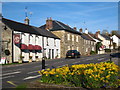
1
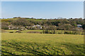
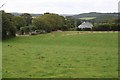
Top of Mill Lane in North Grampound
A photo from the unclassified road between Grampound and Grampound Road looking back at the east side of the village on the hill towards St Austell. The houses are on Mill Lane which is a cul-de-sac.
Image: © Mike Lyne
Taken: 11 Apr 2020
0.03 miles
2
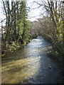
The River Fal above the bridge at Grampound
Grampound was an important town because of its position as a crossing point on the Fal.
Image: © Rod Allday
Taken: 8 Apr 2010
0.12 miles
3
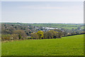
East side of Grampound
A photo from the unclassified road between Grampound and Grampound Road looking back at the east side of the village on the hill towards St Austell.
Image: © Mike Lyne
Taken: 11 Apr 2020
0.13 miles
4
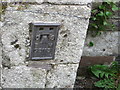
Ordnance Survey Flush Bracket G2113
This bracket can be found on the wall of the school at Grampound. The benchmark height is recorded as being 21.663 metres above sea level.
For more detail see : http://www.bench-marks.org.uk/bm14096
Image: © Peter Wood
Taken: 5 May 2017
0.14 miles
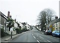
5
Fore Street Grampound
Grampound's linear layout is medieval, with long thin burgage plots extending away from the main street, Fore Street (A390). Most of the village core is a Conservation Area, and there are many listed buildings on Fore Street. Its name is from the Norman French grand (great) and pont (bridge) and it was an important crossing point on the River Fal. It was notorious as a rotten borough, returning two MPs to the House of Commons from the reign of Edward VI until it was disenfranchised in 1821, after a corruption scandal that led to the conviction and imprisonment of several people for bribery.
Image: © Rod Allday
Taken: 8 Apr 2010
0.15 miles
8
Grampound Tollhouse by the A390, Fore Street, Grampound
Tollhouse by the A390, in parish of Grampound with Creed (Restormel District), Toll House, Fore Street, Grampound, TR2 4RX.
Cornwall & Scilly HER.
HER Number: 22980 https://www.heritagegateway.org.uk/Gateway/Results_Single.aspx?uid=MCO26128&resourceID=1020
Surveyed
Milestone Society National ID: CW.GRA02
Image: © Alan Rosevear
Taken: 26 Feb 2009
0.15 miles
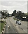
9
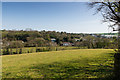
Outside Grampound
On the hillside just to the north of Grampound village.
Image: © Tony Atkin
Taken: 26 Aug 2006
0.15 miles
10
North Grampound
A photo from the unclassified road between Grampound and Grampound Road looking back at the east side of the village on the hill towards St Austell. The houses are on Mill Lane.
Image: © Mike Lyne
Taken: 11 Apr 2020
0.16 miles