IMAGES TAKEN NEAR TO
Ladock, TRURO, TR2 4PW
Introduction
This page details the photographs taken nearby to TR2 4PW by members of the Geograph project.
The Geograph project started in 2005 with the aim of publishing, organising and preserving representative images for every square kilometre of Great Britain, Ireland and the Isle of Man.

There are currently over 7.5m images from over14,400 individuals and you can help contribute to the project by visiting https://www.geograph.org.uk
Image Map
Images are licensed for reuse under creativecommons.org/licenses/by-sa/2.0
Notes
- Clicking on the map will re-center to the selected point.
- The higher the marker number, the further away the image location is from the centre of the postcode.
Image Listing (38 Images Found)
Images are licensed for reuse under creativecommons.org/licenses/by-sa/2.0
Image
Details
Distance
1
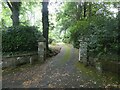
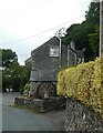
Ladock - Southern entrance to Ladock House
This gateway gives access to the driveway through the extensive grounds of Ladock House - this is private land with no public right-of-way.
Image: © Rob Farrow
Taken: 30 Jul 2022
0.07 miles
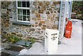
2

Milestone in Ladock village
This road used to be the main route to London from Truro, hence the markings on the milestone. Since the A30 was improved from Fraddon to Carland Cross the Truro traffic now travels that way and Ladock village is now much more peaceful.
Image: © Rod Allday
Taken: 3 Oct 2009
0.09 miles
3
Old Milestone by the B3275 in Ladock
Metal plates attached to stone post by the B3275 (was A39), in parish of LADOCK (CARRICK District), Ladock village, in pavement, on East side of road. Truro iron plate, erected by the Truro turnpike trust in the 19th century.
Inscription reads:-
: TRURO / 7 / FALMOUTH / 17½ : : BODMIN / 17¼ / LONDON / 243 :
Grade II Listed. List Entry Number: 1396478
https://historicengland.org.uk/listing/the-list/list-entry/1396478
Milestone Society National ID: CW_BMTO17.
Image: © Ian Thompson
Taken: 1 Jun 1996
0.09 miles
4
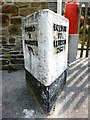
Old Milestone by the B3275 in Ladock
Metal plates attached to stone post by the B3275 (was A39), in parish of LADOCK (CARRICK District), Ladock village, in pavement, on East side of road. Truro iron plate, erected by the Truro turnpike trust in the 19th century.
Inscription reads:-
: TRURO / 7 / FALMOUTH / 17½ : : BODMIN / 17¼ / LONDON / 243 :
Grade II listed.
List Entry Number: 1396478 https://historicengland.org.uk/listing/the-list/list-entry/1396478
Milestone Society National ID: CW_BMTO17.
Image: © Rosy Hanns
Taken: 12 Apr 2019
0.09 miles
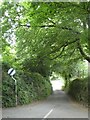
5

B3275 South of Ladock. Looking north
Until the improvements to the A30 to the north this was the main road between Truro and Bodmin.
Image: © Fred James
Taken: 31 Oct 2008
0.09 miles
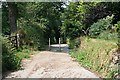
6
Ladock - The lane to Probus
This little lane branches off southwards from the lane which runs to the south of Ladock. It wiggles its way to the village of Probus via various hamlets and farms.
Image: © Rob Farrow
Taken: 30 Jul 2022
0.10 miles
7
Ladock - Bissick Old Mill from the south
Walking northwards along a back lane in Ladock, this is the end-on view of Image
The old corn mill dating from the C17th is now a Guest House - their website https://www.bissickoldmill.co.uk
Image: © Rob Farrow
Taken: 30 Jul 2022
0.10 miles
8
Steep Hill to the Valley Bottom
Ladock Church and School are high on the valley side, the heart of the village is down in the valley bottom and the two are linked by this steep narrow road from which motor vehicles have been thankfully banished to a more boring route. This photograph shows the top of the road just before it disappears into a steep slope between the trees.
Image: © Tony Atkin
Taken: 1 Jul 2006
0.10 miles
9
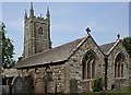
Ladock Church
First dedicated in 1268 this church underwent its last major restoration in 1864.
Image: © Tony Atkin
Taken: 1 Jul 2006
0.10 miles
10

Ladock - Roadside wild flowers
This pretty assortment of wild flowers were growing by the side of the main road through Ladock, the B3275.
The blue cornflowers are the most prevalent, but amongst them there are red poppies and a white flower which may be a white cosmos, while the purple flower may be another cosmos e.g. Cosmos bipinnatus. Thanks to fellow Geographers for help in identifying the latter two flowers.
This collection has almost certainly been intentionally grown here by the scattering of seed in the wayside, especially as the Cosmos species are not native to the UK.
Image: © Rob Farrow
Taken: 31 Jul 2022
0.11 miles