IMAGES TAKEN NEAR TO
Trelyon, TRURO, TR2 4ES
Introduction
This page details the photographs taken nearby to Trelyon, TR2 4ES by members of the Geograph project.
The Geograph project started in 2005 with the aim of publishing, organising and preserving representative images for every square kilometre of Great Britain, Ireland and the Isle of Man.

There are currently over 7.5m images from over14,400 individuals and you can help contribute to the project by visiting https://www.geograph.org.uk
Image Map
Images are licensed for reuse under creativecommons.org/licenses/by-sa/2.0
Notes
- Clicking on the map will re-center to the selected point.
- The higher the marker number, the further away the image location is from the centre of the postcode.
Image Listing (7 Images Found)
Images are licensed for reuse under creativecommons.org/licenses/by-sa/2.0
Image
Details
Distance
1
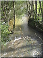
The River Fal at Tolgarrick
Looking downstream from the road bridge.
Image: © Rod Allday
Taken: 4 Apr 2009
0.11 miles
2
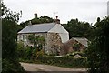
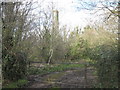
House at Tolgarrick Mill
This is in the bottom of the River Fal Valley. There is an old mine chimney peeping out from behind the trees.
Image: © Tony Atkin
Taken: 26 Aug 2006
0.13 miles
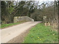
4
Farmland, St Stephen-in-Brannel
The chimney at Tolgarrick lurks in woodland beside the River Fal.
Image: © Andrew Smith
Taken: 9 May 2019
0.15 miles
5
Chimney at Tolgarrick
Presumably associated with Tolgarrick Uranium Mine.
Image: © Rod Allday
Taken: 4 Apr 2009
0.16 miles
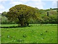
6
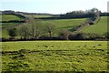
Pasture, St Stephen-in-Brannel
A view from the lane to the west of Trelyon.
Image: © Andrew Smith
Taken: 18 Mar 2022
0.21 miles
7
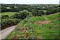
The Fal Valley by Trelion
This is a green and pleasant part of the valley now, but it used to be a mining area.
Image: © Tony Atkin
Taken: 26 Aug 2006
0.22 miles