IMAGES TAKEN NEAR TO
Merther Lane, TRURO, TR2 4AQ
Introduction
This page details the photographs taken nearby to Merther Lane, TR2 4AQ by members of the Geograph project.
The Geograph project started in 2005 with the aim of publishing, organising and preserving representative images for every square kilometre of Great Britain, Ireland and the Isle of Man.

There are currently over 7.5m images from over14,400 individuals and you can help contribute to the project by visiting https://www.geograph.org.uk
Image Map
Images are licensed for reuse under creativecommons.org/licenses/by-sa/2.0
Notes
- Clicking on the map will re-center to the selected point.
- The higher the marker number, the further away the image location is from the centre of the postcode.
Image Listing (18 Images Found)
Images are licensed for reuse under creativecommons.org/licenses/by-sa/2.0
Image
Details
Distance
1
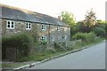
Cottages, Merther Lane
Shaded from low morning sun. The terrace of estate cottages is listed and described at https://www.historicengland.org.uk/listing/the-list/list-entry/1218926 .
Image: © Derek Harper
Taken: 19 Jul 2016
0.05 miles
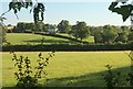
2

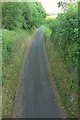
Approaching Merther Lane
A tree-lined stretch of lane in the southeast corner of the square, bordering the flower fields at Fentongollan on the left.
Image: © Derek Harper
Taken: 19 Jul 2016
0.07 miles
3
Lesparrow and farmland
The house at Lesparrow straddles a grid line; the left half is in this square. "Probably late C18" https://www.historicengland.org.uk/listing/the-list/list-entry/1141063 . This view looks to the right from the same spot as Image
Image: © Derek Harper
Taken: 19 Jul 2016
0.08 miles
4
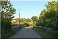
Bridge over drive to Tregothnan
The road through Merther Lane crosses the estate carriage drive on this listed bridge https://www.historicengland.org.uk/listing/the-list/list-entry/1141062 .
Image: © Derek Harper
Taken: 19 Jul 2016
0.10 miles
5
Tregothnan carriage drive
Image: © Derek Harper
Taken: 19 Jul 2016
0.11 miles
6
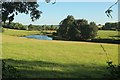
Pond near Tregonian
From the lane between Tregonian and Trewonnal. The Tregothnan carriage drive runs past the pond and the trees. Houses at Merther lane can be seen beyond.
Image: © Derek Harper
Taken: 19 Jul 2016
0.12 miles
7
Tregothnan carriage drive
Image: © Derek Harper
Taken: 19 Jul 2016
0.12 miles
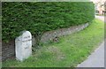
8
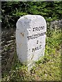
Old Milestone in Merther Lane, St Michael Penkevil
Carved stone post by the UC road, in parish of ST MICHAEL PENKEVIL (CARRICK District), Merther Lane, outside cottage; West of phone box and bridge, on the verge, back to stone wall, on West side of road. Tregothnan stone, erected by a private estate in the 19th century.
Inscription reads:-
FROM
TREGOTHNAN
1
MILE
Carved benchmark on front lower face.
Grade II Listed. List Entry Number: 1396481
https://historicengland.org.uk/listing/the-list/list-entry/1396481
Milestone Society National ID: CW_TT01.
Image: © Ian Thompson
Taken: Unknown
0.13 miles
9
Old Milestone in Merther Lane, St Michael Penkevil
Carved stone post by the UC road, in parish of ST MICHAEL PENKEVIL (CARRICK District), Merther Lane, outside cottage; West of phone box and bridge, on the verge, back to stone wall, on West side of road. Tregothnan stone, erected by a private estate in the 19th century.
Inscription reads:-
FROM
TREGOTHNAN
1
MILE
Carved benchmark on front lower face.
Grade II Listed.
List Entry Number: 1396481 https://historicengland.org.uk/listing/the-list/list-entry/1396481
Milestone Society National ID: CW_TT01.
Image: © Rosy Hanns
Taken: 24 May 2019
0.13 miles
10
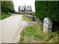
Milestone, Merther Lane
Unusually detailed information is given at the listed building description https://www.historicengland.org.uk/listing/the-list/list-entry/1396481 for this milestone: "one of a set of four erected privately to mark the approach to Tregothnan House ... from the north-east". It is also visible in Image
Image: © Derek Harper
Taken: 19 Jul 2016
0.13 miles