IMAGES TAKEN NEAR TO
St. Michael Penkivel, TRURO, TR2 4AH
Introduction
This page details the photographs taken nearby to TR2 4AH by members of the Geograph project.
The Geograph project started in 2005 with the aim of publishing, organising and preserving representative images for every square kilometre of Great Britain, Ireland and the Isle of Man.

There are currently over 7.5m images from over14,400 individuals and you can help contribute to the project by visiting https://www.geograph.org.uk
Image Map
Images are licensed for reuse under creativecommons.org/licenses/by-sa/2.0
Notes
- Clicking on the map will re-center to the selected point.
- The higher the marker number, the further away the image location is from the centre of the postcode.
Image Listing (23 Images Found)
Images are licensed for reuse under creativecommons.org/licenses/by-sa/2.0
Image
Details
Distance
1

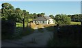
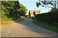
Field near Tregonian
From the lane shown in Image, looking left. The trees on the left are along the lane to Merther Lane.
Image: © Derek Harper
Taken: 19 Jul 2016
0.04 miles
2
Cottages, Tregonian
From the lane to Trewonnal. Tregonian Farmhouse, now divided into two cottages, is at least C17, is listed, and described at https://www.historicengland.org.uk/listing/the-list/list-entry/1141061 .
Image: © Derek Harper
Taken: 19 Jul 2016
0.04 miles
4
Lane past Tregonian
With the start of footpath 323 4/1 to Malpas Point.
Image: © Derek Harper
Taken: 19 Jul 2016
0.05 miles
5

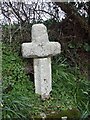
Old Wayside Cross
Fentongollan Cross, a wayside cross, with old head & shaft. At a t junction near Tregonian. St Michael Penkevil parish. Langdon MC No. 72. Grade II Listed https://historicengland.org.uk/listing/the-list/list-entry/1141092. See also http://www.flickr.com/photos/ocifant/2951995214.
Milestone Society National ID: CWCA_SMP02
Image: © L Nott
Taken: 24 Aug 2019
0.07 miles
6
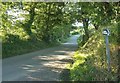
Lane leading to Malpas Ferry
In my youth Malpas was always pronounced Mopus by us locals and was very often written as such. The admiralty charts used to show the stretch of water down river as Mopus Reach.
Image: © Fred James
Taken: 28 Feb 2007
0.08 miles
7

St Michael Penkivel School
Mapped as a chapel but built (c 1888) as a school, the cruciform design lending itself to gender segregation. The separate earth closet buildings, also specified in the listed building description https://www.historicengland.org.uk/listing/the-list/list-entry/1218921 , alas I failed to capture. But the "Original rubble boundary walls with granite dressings and contemporary iron railings and gates to south side" are shown here.
The postbox is George V, number TR1 137.
Image: © Derek Harper
Taken: 19 Jul 2016
0.13 miles
8
St Michael Penkivel School
A more distant shot of Image from close to the bridge over the Tregothnan carriage drive shown in Image The milestone shown in Image] is just before the driveway entrance on the right.
Image: © Derek Harper
Taken: 19 Jul 2016
0.13 miles
9

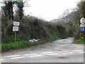
Field near Merther Lane
With a view towards the Tresillian River.
Image: © Derek Harper
Taken: 19 Jul 2016
0.13 miles
10
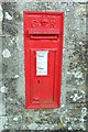
Postbox, St Michael Penkivel School
This George V postbox, number TR1 137, is on the return wall visible in Image
Image: © Derek Harper
Taken: 19 Jul 2016
0.13 miles