
IMAGES TAKEN NEAR TO
Buzza Hill, ISLES OF SCILLY, TR21 0NQ
Introduction
This page details the photographs taken nearby to Buzza Hill, TR21 0NQ by members of the Geograph project.
The Geograph project started in 2005 with the aim of publishing, organising and preserving representative images for every square kilometre of Great Britain, Ireland and the Isle of Man.

There are currently over 7.5m images from over14,400 individuals and you can help contribute to the project by visiting https://www.geograph.org.uk
Image Map
Images are licensed for reuse under creativecommons.org/licenses/by-sa/2.0
Notes
- Clicking on the map will re-center to the selected point.
- The higher the marker number, the further away the image location is from the centre of the postcode.
Image Listing (259 Images Found)
Images are licensed for reuse under creativecommons.org/licenses/by-sa/2.0
Image
Details
Distance
1
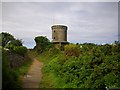
Buzza Tower
Built as a windmill in 1834 to replace the Peninnis Mill, but maintained as a memorial since 1912 to King Edward's visit. It was named King Edward's Tower, but is commonly known now as the Buzza Tower. It is close to a hilltop chambered cairn and may be erected on top of another. It provides splendid views all round and shelter from the wind and driving rain.
Image: © Bob Embleton
Taken: 6 Aug 2008
0.00 miles
2
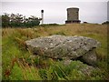
Buzza Hill, St. Mary's
Three ages - three landmarks. An ancient chambered cairn, known as an entrance grave, whose mound would have been visible from all land and sea around. A 19th century windmill converted to a memorial to King Edward has been a landmark for over 160 years. The island has its own power generator and its chimney is the landmark of the modern era.
Image: © Bob Embleton
Taken: 6 Aug 2008
0.01 miles
3
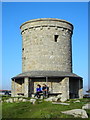
The Buzza Tower
The windmill was constructed in 1821 on the site of a Bronze Age kerbed cairn previously excavated by William Borlase in 1752. It was restored and extended in 1911 to mark a visit by King Edward VII.
In 2014 the tower became home to the Scilly Camera Obscura and 'cabinet of curiosities'.
Image: © Mark Percy
Taken: 14 Apr 2015
0.02 miles
4
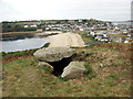
Buzza Hill
Burial chamber atop the hill, looking over Hugh Town below.
Image: © Alan Simkins
Taken: Unknown
0.03 miles
6

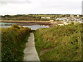
Hugh Town from Buzza Hill
Looking north west towards St Mary's Harbour.
Image: © Andrew Abbott
Taken: 5 May 2018
0.04 miles
7
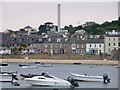
Hugh Town & St Mary's Power Station, Isles Of Scilly
A view from the main pier over to Hugh Town and the diesel power station on St Mary's.
Image: © James T M Towill
Taken: 12 Jul 2011
0.05 miles
8
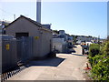
Electric Power Depot
This installation was formerly the electric power generation plant for the Isles of Scilly but it is now a back-up facility with the islands receiving power from the National Grid by undersea cable.
Image: © Michael Steele
Taken: 12 May 2015
0.05 miles
10

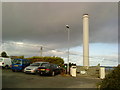
Old quarry, Porthcressa, St. Mary's
Above the eastern end of Porthcressa Beach. Tidied up for use as a picnic area with a picnic table and litter bin, but, sadly, not tended to recently. Accessed from the path up to the Buzza Tower.
Image: © Bob Embleton
Taken: 6 Aug 2008
0.06 miles