IMAGES TAKEN NEAR TO
St. Mary's, ISLES OF SCILLY, TR21 0AB
Introduction
This page details the photographs taken nearby to TR21 0AB by members of the Geograph project.
The Geograph project started in 2005 with the aim of publishing, organising and preserving representative images for every square kilometre of Great Britain, Ireland and the Isle of Man.

There are currently over 7.5m images from over14,400 individuals and you can help contribute to the project by visiting https://www.geograph.org.uk
Image Map
Images are licensed for reuse under creativecommons.org/licenses/by-sa/2.0
Notes
- Clicking on the map will re-center to the selected point.
- The higher the marker number, the further away the image location is from the centre of the postcode.
Image Listing (12 Images Found)
Images are licensed for reuse under creativecommons.org/licenses/by-sa/2.0
Image
Details
Distance
1
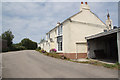
Normandy Farmhouse
The A3110 at Normandy on St. Mary's
Image: © Richard Croft
Taken: 30 Jun 2010
0.03 miles
2
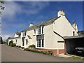
Cottage in Normandy
On Carn Friars Road
Image: © Andrew Abbott
Taken: 5 May 2018
0.03 miles
3
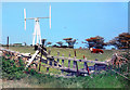
Former Wind Turbine at Mount Todden
I took this picture of a wind turbine on our first visit to Scilly back in the mid 1990s. On our next visit it wasn't there any more and I was told it had been blown down. I can't find any other pictures of it on the web.
From a print and the colours have aged a bit. Also the exact date is uncertain.
Thanks to Roger Banfield and Kate Hale via the Isles of Scilly Museum for help in locating the site and providing extra information, including confirmation of the storm damage story as follows.
"Having put this out to the informed locals, it would appear that it did indeed blow down."
"The wind turbine eventually came apart, and was then dismantled. As there was a large electricity transformer next to it, the Council then installed the desalination plant in the same area (Mount Todden), in the early 1990's. The desalination plant needed a 90Kw supply for the twin units installed."
Image: © Des Blenkinsopp
Taken: Unknown
0.12 miles
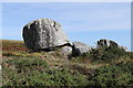
4

New or renovated building
On Normandy Down
Image: © Andrew Abbott
Taken: 3 Oct 2016
0.16 miles
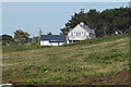
5

New house on Normandy Down
On St Mary's, Isles of Scilly
Image: © Andrew Abbott
Taken: 3 Oct 2016
0.18 miles
9
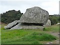
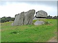
Balanced on three points
A rock balanced on three points on Normandy Down
Image: © Andrew Abbott
Taken: 3 Oct 2016
0.20 miles