IMAGES TAKEN NEAR TO
Nancledra, PENZANCE, TR20 8BE
Introduction
This page details the photographs taken nearby to TR20 8BE by members of the Geograph project.
The Geograph project started in 2005 with the aim of publishing, organising and preserving representative images for every square kilometre of Great Britain, Ireland and the Isle of Man.

There are currently over 7.5m images from over14,400 individuals and you can help contribute to the project by visiting https://www.geograph.org.uk
Image Map (Loading...)


Getting Data...Please wait
Leaflet Map data © OpenStreetMap
Images are licensed for reuse under creativecommons.org/licenses/by-sa/2.0
Notes
- Clicking on the map will re-center to the selected point.
- The higher the marker number, the further away the image location is from the centre of the postcode.
Image Listing (16 Images Found)
Images are licensed for reuse under creativecommons.org/licenses/by-sa/2.0
Image
Details
Distance

2
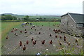
Did someone say food? (1)
There were a few chickens around as I took this photo. They were all running towards me as though I had food or something they were expecting. There word quickly got around because 20 seconds later Image]
Image: © Graham Horn
Taken: 6 Jul 2011
0.02 miles
3
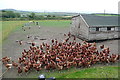
Did someone say food? (2)
There were a few chickens around as I took the previous photo Image The word quickly got around because this was the scene 20 seconds later. Were they expecting food from me?
Image: © Graham Horn
Taken: 6 Jul 2011
0.02 miles

5
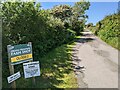
The lane to Higher Trenowin Farm
'Higher Trenowin' appears twice on the 1:25k OS map for this area, but the farm is not named.
Image: © David Medcalf
Taken: 13 Jun 2021
0.07 miles

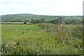
8

Arable land at Higher Trenowin
The cut has been made and it seems as though some bales have already been removed from the field as there are not as many there as I would expect. In the distance is Trencrom Hill Image
Image: © Graham Horn
Taken: 6 Jul 2011
0.13 miles
9
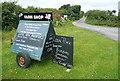
Farm shop at Higher Trenowin Farm
Actually it's that lane that leads to the farm and the shop. This trailer is strategically placed on the main road.
Image: © Graham Horn
Taken: 6 Jul 2011
0.15 miles
10
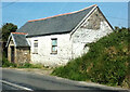
Pump house at Four Winds
The map records nothing exceptional about this building, which may be a pump house. We are overlooking the Red River valley.
Image: © Graham Horn
Taken: 6 Jul 2011
0.20 miles