IMAGES TAKEN NEAR TO
Nancledra, PENZANCE, TR20 8AY
Introduction
This page details the photographs taken nearby to TR20 8AY by members of the Geograph project.
The Geograph project started in 2005 with the aim of publishing, organising and preserving representative images for every square kilometre of Great Britain, Ireland and the Isle of Man.

There are currently over 7.5m images from over14,400 individuals and you can help contribute to the project by visiting https://www.geograph.org.uk
Image Map (Loading...)


Getting Data...Please wait
Leaflet Map data © OpenStreetMap
Images are licensed for reuse under creativecommons.org/licenses/by-sa/2.0
Notes
- Clicking on the map will re-center to the selected point.
- The higher the marker number, the further away the image location is from the centre of the postcode.
Image Listing (8 Images Found)
Images are licensed for reuse under creativecommons.org/licenses/by-sa/2.0
Image
Details
Distance
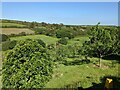
1
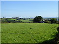
Field at Borea
In the distance on the right is Image
Image: © Rod Allday
Taken: 27 Sep 2018
0.06 miles
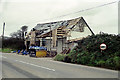
2
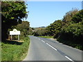
The B3311 entering Nancledra
The main route between Penzance and St Ives.
Image: © Rod Allday
Taken: 27 Sep 2018
0.09 miles
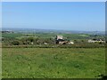
3
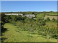
Looking across the orchard to Nancledra
Image: © David Medcalf
Taken: 13 Jun 2021
0.10 miles
6
Carn Pottery
This is the old Primitive Methodist chapel. It was the chapel my mum and aunt went to in the 1930s and 1940s. We lived opposite in a cottage called Ferndale Cottage, locals called it "the pig with one ear".
Image: © Jim Thompson
Taken: 5 Nov 2000
0.15 miles
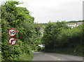
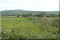
7
Good grassland and an interesting-looking house
Above Nancledra
Image: © David Medcalf
Taken: 13 Jun 2021
0.17 miles
8
Pump house at Four Winds
The map records nothing exceptional about this building, which may be a pump house. We are overlooking the Red River valley.
Image: © Graham Horn
Taken: 6 Jul 2011
0.18 miles