IMAGES TAKEN NEAR TO
South Place Gardens, PENZANCE, TR19 7UJ
Introduction
This page details the photographs taken nearby to South Place Gardens, TR19 7UJ by members of the Geograph project.
The Geograph project started in 2005 with the aim of publishing, organising and preserving representative images for every square kilometre of Great Britain, Ireland and the Isle of Man.

There are currently over 7.5m images from over14,400 individuals and you can help contribute to the project by visiting https://www.geograph.org.uk
Image Map
Images are licensed for reuse under creativecommons.org/licenses/by-sa/2.0
Notes
- Clicking on the map will re-center to the selected point.
- The higher the marker number, the further away the image location is from the centre of the postcode.
Image Listing (142 Images Found)
Images are licensed for reuse under creativecommons.org/licenses/by-sa/2.0
Image
Details
Distance
3
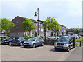
Car Park and Flats near St Just Fire Station
Image: © Gary Rogers
Taken: 26 May 2018
0.10 miles
5
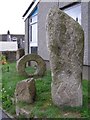
Stone sculptures outside St Just library
The three stones on the left are some kind of artistic tribute to the ancient Men an Tol stones in nearby square SW4234. The taller stone on the right is another modern sculpture featuring a zig-zag pattern - it probably refers to a local menhir. Both sculptures stand in front of the pebbledashed St Just library on Market Street, opposite the car park and bus station. The sculptor is Rory te Tigo - his work can be seen around the St Just area, including a series of granite sculptures alongside the A30 between Sennen and Lands End.
Image: © Jim Champion
Taken: 25 Aug 2006
0.11 miles
7
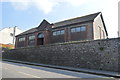
St Just Community Centre
The newly formed county Territorial Association adopted a similar design for a number of drill halls built in 1911. (Camelford, Hayle)
Image: © John M
Taken: 9 Sep 2014
0.11 miles
8
Fore Street, St Just
The main road into the town, part of the A3071.
Image: © Bill Boaden
Taken: 11 Jul 2014
0.11 miles
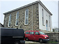
9
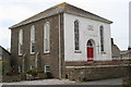
St Just Methodist Free Church
Built in 1860. One of the many variations of Methodism, in 1907 the United Methodist Free Church merged with the Methodist New Connexion and the Bible Christians to form the United Methodist Church. In 1932 the United Methodists joined with the Wesleyan Methodists and the Primitive Methodists to form the Methodist Church of Great Britain.
Image: © Rod Allday
Taken: 12 May 2009
0.12 miles
10
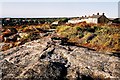
Carn Bosavern
Carn Gloose is a large piece of granite with views over St.Just and all around.
Image: © jonathanpolkest
Taken: 9 May 2008
0.13 miles