IMAGES TAKEN NEAR TO
Levant Road, PENZANCE, TR19 7SX
Introduction
This page details the photographs taken nearby to Levant Road, TR19 7SX by members of the Geograph project.
The Geograph project started in 2005 with the aim of publishing, organising and preserving representative images for every square kilometre of Great Britain, Ireland and the Isle of Man.

There are currently over 7.5m images from over14,400 individuals and you can help contribute to the project by visiting https://www.geograph.org.uk
Image Map
Images are licensed for reuse under creativecommons.org/licenses/by-sa/2.0
Notes
- Clicking on the map will re-center to the selected point.
- The higher the marker number, the further away the image location is from the centre of the postcode.
Image Listing (64 Images Found)
Images are licensed for reuse under creativecommons.org/licenses/by-sa/2.0
Image
Details
Distance
1
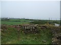
Top of the shaft at Higher Bal
House at Trewellard in the background. The shaft is grated but it is still a stomach churning experience to look down it as it is several thousand feet deep.
Image: © M Hunter
Taken: 3 Aug 2008
0.01 miles
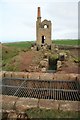
2
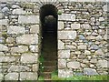
Steps up to the shaft at Higher Bal
These steps lead up to the top of the shaft at Higher Bal. The enormous masonry structure is reminiscent more of a castle from the dark ages than a 19th century industrial structure.
Image: © M Hunter
Taken: 3 Aug 2008
0.01 miles
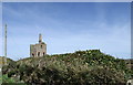
3
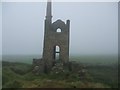
Higher Bal Mine looming out of the mist
This picture was taken On August 3rd 2008 in what must be one of the worst summers in living memory
Image: © M Hunter
Taken: 3 Aug 2008
0.02 miles
4
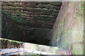
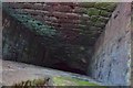
Mine shaft, Levant Higher Bal
This is a view down Guide Shaft at Higher Bal, used for pumping and winding. Access to this viewing point is via the short arched tunnel that leads from the side of Levant Road, just below Trewellard.
Image: © John Gibson
Taken: 28 Feb 2008
0.04 miles
5
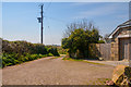
Cornwall : Track
A track heading off from Levant Road.
Image: © Lewis Clarke
Taken: 21 Apr 2018
0.04 miles
6
Levant Higher Bal
This 35" winding and pumping engine house worked Guide Shaft, underneath the safety grill in the foreground. Higher Bal was originally Spearne Consols and was incorporated with Levant Mine in 1877. The site has been consolidated and made safe in recent years by the National Trust.
Image: © John Gibson
Taken: 28 Feb 2008
0.05 miles
8
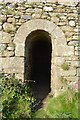
Higher Bal Mine - Levant
Shaft entrance.
Originally Spearne Consols, this sett was absorbed by Levant Mine in 1877 and became known as Higher Bal (bal = mine in Cornish). It lies beside the little road from Trewellard to the main Levant site. The engine house contained a 35" cylinder Cornish engine that pumped and wound from Guide Shaft,
John Gibson
Image: © Ashley Dace
Taken: 5 Sep 2012
0.05 miles
9
Guide Shaft - Higher Bal
Originally Spearne Consols, this sett was absorbed by Levant Mine in 1877 and became known as Higher Bal (bal = mine in Cornish). It lies beside the little road from Trewellard to the main Levant site. The engine house contained a 35" cylinder Cornish engine that pumped and wound from Guide Shaft.
John Gibson
Image: © Ashley Dace
Taken: 5 Sep 2012
0.05 miles
10
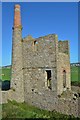
Higher Bal Mine - Levant
Originally Spearne Consols, this set was absorbed by Levant Mine in 1877 and became known as Higher Bal (bal = mine in Cornish). It lies beside the little road from Trewellard to the main Levant site. The engine house contained a 35" cylinder Cornish engine that pumped and wound from Guide Shaft.
John Gibson
Image: © Ashley Dace
Taken: 5 Sep 2012
0.05 miles