IMAGES TAKEN NEAR TO
Paul, PENZANCE, TR19 6UY
Introduction
This page details the photographs taken nearby to TR19 6UY by members of the Geograph project.
The Geograph project started in 2005 with the aim of publishing, organising and preserving representative images for every square kilometre of Great Britain, Ireland and the Isle of Man.

There are currently over 7.5m images from over14,400 individuals and you can help contribute to the project by visiting https://www.geograph.org.uk
Image Map
Images are licensed for reuse under creativecommons.org/licenses/by-sa/2.0
Notes
- Clicking on the map will re-center to the selected point.
- The higher the marker number, the further away the image location is from the centre of the postcode.
Image Listing (19 Images Found)
Images are licensed for reuse under creativecommons.org/licenses/by-sa/2.0
Image
Details
Distance
2
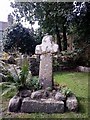
Old Wayside Cross in Kerris, Paul parish
Kerris Cross, old head and shaft, Langdon WP No.78 by the wayside, in parish of Paul (Penwith District), 15m East of Kerris Manor Farmhouse.
Grade II listed.
List Entry Number: 1327507 https://historicengland.org.uk/listing/the-list/list-entry/1327507
Scheduled Monument.
List Entry Number: 1004491 https://historicengland.org.uk/listing/the-list/list-entry/1004491
To be surveyed
Milestone Society National ID: CWPW_PAU07
Image: © Milestone Society
Taken: Unknown
0.04 miles
4
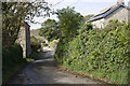
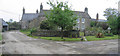
Approaching Kerris
Approaching the farming hamlet of Kerris.
Image: © Elizabeth Scott
Taken: 6 Oct 2012
0.06 miles
5
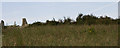
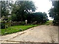
Site of the ancient settlement at Kerris
This site of ancient enclosure or fortification is sometimes known as Kerris Roundago. Place-name scholars are not entirely certain of the derivation of the name Kerris. P.A.S. Pool says it comes from Cornish ke (hedge) and means "enclosure". O.J. Padel considers the likelihood of a derivation from the past participle of a hypothetical verb "to fortify", but concludes that this is very doubtful.
Image: © Elizabeth Scott
Taken: 6 Oct 2012
0.06 miles
6
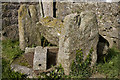
Well at Kerris
The hole in the ground has been covered and a stone weighs down the cover. I assume that the two vertical pieces of granite with slots in the top would once have held a spindle mechanism to draw a bucket of water up. The fallen slab of granite at the back may once have been a cover for the whole thing.
Image: © Elizabeth Scott
Taken: 6 Oct 2012
0.07 miles
7
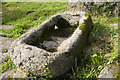
Animals' drinking trough at Kerris
This drinking trough for animals is right in front of the well. I assume it would have regularly been replenished with water from the well.
Image: © Elizabeth Scott
Taken: 6 Oct 2012
0.07 miles
9
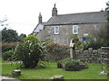
Kerris
Looking west to Kerris(?) Farm. An old cross can be seen on the right of the green.
Image: © Alan Simkins
Taken: 25 May 2006
0.08 miles
10
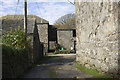
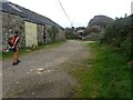
Farm buildings at Kerris
Farmyard entrance.
Image: © Elizabeth Scott
Taken: 6 Oct 2012
0.09 miles