IMAGES TAKEN NEAR TO
St. Levan, PENZANCE, TR19 6JH
Introduction
This page details the photographs taken nearby to TR19 6JH by members of the Geograph project.
The Geograph project started in 2005 with the aim of publishing, organising and preserving representative images for every square kilometre of Great Britain, Ireland and the Isle of Man.

There are currently over 7.5m images from over14,400 individuals and you can help contribute to the project by visiting https://www.geograph.org.uk
Image Map
Images are licensed for reuse under creativecommons.org/licenses/by-sa/2.0
Notes
- Clicking on the map will re-center to the selected point.
- The higher the marker number, the further away the image location is from the centre of the postcode.
Image Listing (6 Images Found)
Images are licensed for reuse under creativecommons.org/licenses/by-sa/2.0
Image
Details
Distance
1

Snowy vista, Polgigga
Snow clouds clearing away, but more came later
Image: © Frances Watts
Taken: 2 Feb 2009
0.08 miles
2
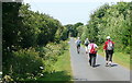
Footpath west of Polgigga
A group of walkers enjoys the straight, level and tarmaced sufrace of this footpath west of Polgigga, that leads towards Bosistow then Mill Bay.
Image: © Graham Horn
Taken: 4 Jul 2011
0.11 miles
3
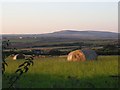
From the track to Lower Bosistow
Chapel Carn Brea is the hill in the distance
Image: © Frances Watts
Taken: 18 Jul 2006
0.16 miles
5
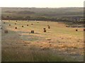
Summer evening, near Polgigga
Taken from the track to Lower Bosistow
Image: © Frances Watts
Taken: 18 Jul 2006
0.20 miles
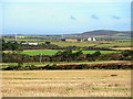
6
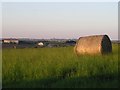
Polgigga on a summer evening
The nearby cluster of houses is the hamlet of Polgigga. St Buryan church tower is on the horizon.
Image: © Frances Watts
Taken: 18 Jul 2006
0.21 miles