IMAGES TAKEN NEAR TO
Windmill Way, TR19 6FE
Introduction
This page details the photographs taken nearby to Windmill Way, TR19 6FE by members of the Geograph project.
The Geograph project started in 2005 with the aim of publishing, organising and preserving representative images for every square kilometre of Great Britain, Ireland and the Isle of Man.

There are currently over 7.5m images from over14,400 individuals and you can help contribute to the project by visiting https://www.geograph.org.uk
Image Map
Images are licensed for reuse under creativecommons.org/licenses/by-sa/2.0
Notes
- Clicking on the map will re-center to the selected point.
- The higher the marker number, the further away the image location is from the centre of the postcode.
Image Listing (105 Images Found)
Images are licensed for reuse under creativecommons.org/licenses/by-sa/2.0
Image
Details
Distance
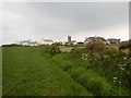
2
Awaiting their turn
Show dogs at St Buryan Vintage Rally.
Image: © Rod Allday
Taken: 25 Jul 2009
0.08 miles
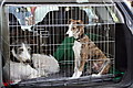
3
Massey Ferguson 35 tractor
Perhaps the classic 'little red tractor' of British agriculture. Hundreds of thousands of these Massey Ferguson TO35s were built at the Banner Lane factory in Coventry between 1956 and 1964; most were powered by a Perkins 2.5litre diesel engine. The basic model is still in production for sale in Africa, branded as the 'People's Tractor'
Image: © Richard Law
Taken: 26 Dec 2015
0.12 miles
5
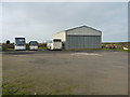
First and Last Coaches
A small bus company located at St Buryan, and their workshop which was closed for the Christmas period.
Image: © Richard Law
Taken: 26 Dec 2015
0.12 miles
6
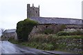
Dilapilapidated barn in St Buryan
A dilapilapidated barn with the tower of St Buryan church in the background.
Image: © Philip Halling
Taken: 6 Nov 2017
0.13 miles
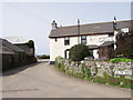
7
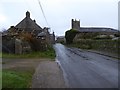
Road entering St Buryan
Entering the village of St Buryan from this direction visitors' first impressions are not good, with run down and dilapidated buildings on both sides of the road.
Image: © Philip Halling
Taken: 6 Nov 2017
0.13 miles
8
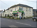
The only shop in the village
Since the demise of the former Post Office across the road Image whose business has now been transferred to this Londis, Jackson's is now the only retail outlet in St Buryan.
Image: © Richard Law
Taken: 26 Dec 2015
0.14 miles
9
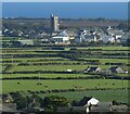
St Buryan from Chapel Carn Brea
The views from the top of Chapel Carn Brea are excellent. This is looking south-eastwards to the village of St Buryan with its eponymous church. The conspicuous tower is 92' high and dates from 1501, though there has been a church on this site since at least 930AD in the reign of Æthelstan.
Even older, in a field below the tower (as viewed) is a prominent standing stone called Trevorgans Menhir at SW 40490 26132 - see Image] and Image] for much closer views of this neolithic relic.
See shared description below:
Image: © Rob Farrow
Taken: 1 Oct 2021
0.15 miles
10
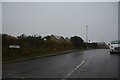
St Buryan : Parc-An-Pearth
Looking along a road.
Image: © Lewis Clarke
Taken: 30 Sep 2022
0.15 miles