IMAGES TAKEN NEAR TO
St. Buryan, PENZANCE, TR19 6EX
Introduction
This page details the photographs taken nearby to TR19 6EX by members of the Geograph project.
The Geograph project started in 2005 with the aim of publishing, organising and preserving representative images for every square kilometre of Great Britain, Ireland and the Isle of Man.

There are currently over 7.5m images from over14,400 individuals and you can help contribute to the project by visiting https://www.geograph.org.uk
Image Map
Images are licensed for reuse under creativecommons.org/licenses/by-sa/2.0
Notes
- Clicking on the map will re-center to the selected point.
- The higher the marker number, the further away the image location is from the centre of the postcode.
Image Listing (14 Images Found)
Images are licensed for reuse under creativecommons.org/licenses/by-sa/2.0
Image
Details
Distance
2
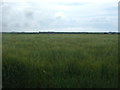
Field near Pendrea
Grassy field surrounded by typical Cornish 'hedges', which are essentially drystone walls topped by a layer of soil & vegetation.
Image: © Richard Law
Taken: 24 Dec 2015
0.16 miles
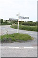
3
The other side of the signpost
See http://www.geograph.org.uk/photo/1301636
Image: © David Medcalf
Taken: 14 Jul 2008
0.16 miles
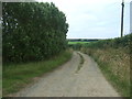
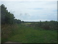
5
The road to Crean
Junction on the B3283 St Buryan to Sparnon road.
Image: © Rod Allday
Taken: 12 May 2009
0.17 miles
6
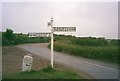
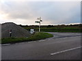
Old Direction Sign - Signpost by the B3283, St Buryan parish
Cone finial - 3 arms; by the B3283, in parish of St Buryan (Penwith District), at the turn to Crean, next to Guide Stone: CW_XSTB2 Image
Surveyed
Milestone Society National ID: CW_SW4024
Image: © Milestone Society
Taken: Unknown
0.17 miles
7
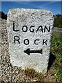
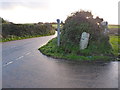
Old Guide Stone by the B3283 at turning to Crean
Carved stone post by the B3283, in parish of St Buryan (Penwith District), at the turn to Crean, next to finger post - MSS id: CW_SW4024 Image
Inscription reads:-
LOGAN
ROCK
{<-arrow}
Grade II listed.
List Entry Number: 1327476 https://historicengland.org.uk/listing/the-list/list-entry/1327476
Surveyed
Milestone Society National ID: CW_XSTB2
Image: © Rosy Hanns
Taken: 5 Jul 2019
0.18 miles
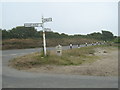
8
Signposts old and new
The original Cornish guide stone (showing St Levan to the left, and Sennen to the right) contrasts with the modern National Cycle Network route sign. The stone has a clear benchmark at its base Image
Image: © Richard Law
Taken: 24 Dec 2015
0.18 miles
9
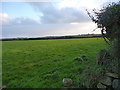
Crean lane junction
The layby beside this junction is currently being used as a store for a supply of surface dressing chips. Fortunately the tipping of these hasn't buried the historic guide stone, which directs travellers to the Logan Rock or St Levan.
Image: © Richard Law
Taken: 24 Dec 2015
0.18 miles