IMAGES TAKEN NEAR TO
Higher Lariggan, PENZANCE, TR18 4NL
Introduction
This page details the photographs taken nearby to Higher Lariggan, TR18 4NL by members of the Geograph project.
The Geograph project started in 2005 with the aim of publishing, organising and preserving representative images for every square kilometre of Great Britain, Ireland and the Isle of Man.

There are currently over 7.5m images from over14,400 individuals and you can help contribute to the project by visiting https://www.geograph.org.uk
Image Map
Images are licensed for reuse under creativecommons.org/licenses/by-sa/2.0
Notes
- Clicking on the map will re-center to the selected point.
- The higher the marker number, the further away the image location is from the centre of the postcode.
Image Listing (76 Images Found)
Images are licensed for reuse under creativecommons.org/licenses/by-sa/2.0
Image
Details
Distance
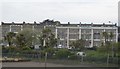
1
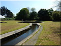
Water Feature on the Lariggin River
Small park near Wherry Town
Image: © James Emmans
Taken: 27 May 2016
0.09 miles
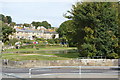
3
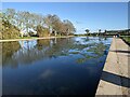
Too much waterweed?
The boating lake provided by the Rotary Club in 1955 is becoming full of weed - perhaps through climate change? It certainly reduces the scope for boating - see: https://www.geograph.org.uk/photo/886962
Image: © David Medcalf
Taken: 3 Jun 2021
0.11 miles
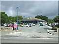
4
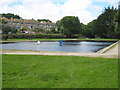
Model boating lake at Wherry Town
This is very popular with model boat enthusiasts and there are often very elaborate radio controlled yachts.
Image: © Rod Allday
Taken: 17 Jul 2008
0.12 miles
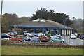
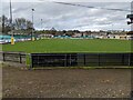
8
Lidl Supermarket, Penzance
On Western Promenade Road.
Image: © JThomas
Taken: 13 Jul 2017
0.14 miles
9
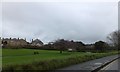
Mann's Field between Newlyn and Penzance
Described as an "Amenity Greenspace" the open area has been landscaped.
Image: © David Smith
Taken: 18 Jan 2014
0.14 miles
10
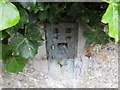
Ordnance Survey Flush Bracket 1816
This broken (vandalised) bracket can be found on a roadside wall at the junction of New Road and Laregan Hill in Newlyn. The benchmark height is recorded as being 7.827 metres above sea level.
For more detail see : http://www.bench-marks.org.uk/bm2044
Image: © Peter Wood
Taken: 1 May 2017
0.14 miles