IMAGES TAKEN NEAR TO
St. Clare Street, PENZANCE, TR18 3DX
Introduction
This page details the photographs taken nearby to St. Clare Street, TR18 3DX by members of the Geograph project.
The Geograph project started in 2005 with the aim of publishing, organising and preserving representative images for every square kilometre of Great Britain, Ireland and the Isle of Man.

There are currently over 7.5m images from over14,400 individuals and you can help contribute to the project by visiting https://www.geograph.org.uk
Image Map
Images are licensed for reuse under creativecommons.org/licenses/by-sa/2.0
Notes
- Clicking on the map will re-center to the selected point.
- The higher the marker number, the further away the image location is from the centre of the postcode.
Image Listing (44 Images Found)
Images are licensed for reuse under creativecommons.org/licenses/by-sa/2.0
Image
Details
Distance
1
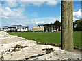
Cricket ground on the site of St Clare's church
Image: © Paul Barnett
Taken: 21 May 2014
0.05 miles
2
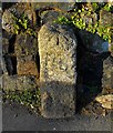
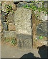
Old Boundary Marker by Nancealverne, Penzance parish
Parish Boundary Marker by the UC road, in parish of Penzance (Penwith District), St Clare, opposite Fire Station, against wall of cricket ground, Northeast side of road.
Inscription not legible.
Large carved bench mark and rivet on top.
Grade II listed.
List Entry Number: 1408102 https://historicengland.org.uk/listing/the-list/list-entry/1408102
To be surveyed
Milestone Society National ID: CW_PZMD01pb
Image: © Milestone Society
Taken: Unknown
0.08 miles
3
Sign of the Times
It is not usual to put a photograph onto geograph showing the same scene as another already on the site Image but in this case I thought the changes between 1995 and 2007 were interesting. The doors are now red rather than white. I'm sure the fire brigade has an explanation for that. More interesting to me however and the change which prompted the title is the addition of a mobile phone mast on the top of the tower.
Image: © Tony Atkin
Taken: 19 Jul 2007
0.08 miles
4
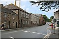
Old Hospital Buildings on Saint Clare Street
These buildings look like they are still used for some things by the hospital but most of the West Cornwall Hospital is housed in new buildings behind these.
Image: © Tony Atkin
Taken: 19 Jul 2007
0.09 miles
5
Outer limits
Original 1687 boundary stone.
Image: © Malcolm Kewn
Taken: 2 Apr 2009
0.10 miles
6
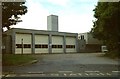
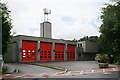
Penzance Fire Station
Penzance Fire Station, St Clare, Penzance, Cornwall.
Image: © Kevin Hale
Taken: 24 Sep 1995
0.11 miles
7
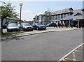
West Cornwall Hospital, Penzance
Main entrance from Penalverne Drive near the corner of Parc Wartha Crescent.
Image: © Jaggery
Taken: 4 Jun 2016
0.12 miles
8
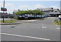
Access road to West Cornwall Hospital, Penzance
From Penalverne Drive towards the main hospital entrance.
Image: © Jaggery
Taken: 4 Jun 2016
0.13 miles
9
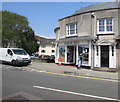
Chyanclare News, Penzance
Shop at 6-7 St Clare Street.
Image: © Jaggery
Taken: 4 Jun 2016
0.14 miles
10
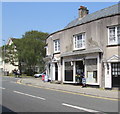
The Middle Shop, Penzance
The Middle Shop in St Clare Street is between Chyanclare News http://www.geograph.org.uk/photo/4982998
on the left and St Clare Street post office http://www.geograph.org.uk/photo/4983008 to the right
Image: © Jaggery
Taken: 4 Jun 2016
0.14 miles