IMAGES TAKEN NEAR TO
Carnmenellis, REDRUTH, TR16 6PR
Introduction
This page details the photographs taken nearby to TR16 6PR by members of the Geograph project.
The Geograph project started in 2005 with the aim of publishing, organising and preserving representative images for every square kilometre of Great Britain, Ireland and the Isle of Man.

There are currently over 7.5m images from over14,400 individuals and you can help contribute to the project by visiting https://www.geograph.org.uk
Image Map
Images are licensed for reuse under creativecommons.org/licenses/by-sa/2.0
Notes
- Clicking on the map will re-center to the selected point.
- The higher the marker number, the further away the image location is from the centre of the postcode.
Image Listing (7 Images Found)
Images are licensed for reuse under creativecommons.org/licenses/by-sa/2.0
Image
Details
Distance
1
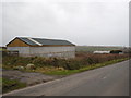
A modern barn at Calvadnack Farm
Very recently constructed.
Image: © Rod Allday
Taken: 4 Feb 2011
0.11 miles
2
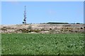
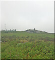
Carnmenellis Down
Almost all the high points in this area of Cornwall appear to have some form of telecommunications mast on them and this is no exception. The mound to the right is a covered reservoir according to the OS map.
Image: © Tony Atkin
Taken: 27 Apr 2006
0.14 miles
4
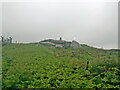
View towards Carnmenellis Trig Point
Image: © thejackrustles
Taken: 21 Jun 2021
0.18 miles
5
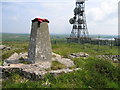
Carnmenellis
Parked at the right angle bend in the road to the West. Follow the track then when you leave it it is brambles. Would be tricky in the summer and certainly not a hill for shorts.
Name: Carnmenellis
Hill number: 2886
Height: 252m / 827ft
Area: 40: Cornwall & Devon
Class: Ma
Grid ref: SW 69563 36448
Summit feature: trig point
Drop: 165m
Col: 87m SW789496
Image: © Rude Health
Taken: 1 Jun 2008
0.18 miles
6
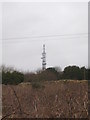
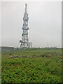
The transmitter mast on Carnmenellis
A microwave transmitting tower, owned and operated by BT.
Image: © Rod Allday
Taken: 4 Feb 2011
0.19 miles