IMAGES TAKEN NEAR TO
Carnmenellis, REDRUTH, TR16 6PP
Introduction
This page details the photographs taken nearby to TR16 6PP by members of the Geograph project.
The Geograph project started in 2005 with the aim of publishing, organising and preserving representative images for every square kilometre of Great Britain, Ireland and the Isle of Man.

There are currently over 7.5m images from over14,400 individuals and you can help contribute to the project by visiting https://www.geograph.org.uk
Image Map (Loading...)


Getting Data...Please wait
Leaflet Map data © OpenStreetMap
Images are licensed for reuse under creativecommons.org/licenses/by-sa/2.0
Notes
- Clicking on the map will re-center to the selected point.
- The higher the marker number, the further away the image location is from the centre of the postcode.
Image Listing (16 Images Found)
Images are licensed for reuse under creativecommons.org/licenses/by-sa/2.0
Image
Details
Distance
1
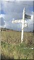
Fingerpost
Milestone Society National ID: CW_SW7035A
Image: © Paul Barnett
Taken: 18 Jan 2023
0.09 miles
2
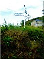
Old Direction Sign - Signpost by Penmarth, Wendron parish
Cone finial - arm 3 has rivetted repair; Visick Cone by the UC road, in parish of Wendron (Kerrier District), Penmarth, behind hedge on raised field.
Grade II listed.
List Entry Number: 1142040 https://historicengland.org.uk/listing/the-list/list-entry/1142040
Surveyed.
Milestone Society National ID: CW_SW7035A
Image: © Milestone Society
Taken: Unknown
0.09 miles
3
Old Direction Sign - Signpost by Penmarth, Wendron parish
Cone finial - arm 3 has rivetted repair; Visick Cone by the UC road, in parish of Wendron (Kerrier District), Penmarth, behind hedge on raised field.
Grade II listed.
List Entry Number: 1142040 https://historicengland.org.uk/listing/the-list/list-entry/1142040
Surveyed.
Milestone Society National ID: CW_SW7035A
Image: © P Barnett
Taken: 24 Oct 2023
0.09 miles
5
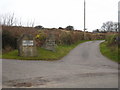
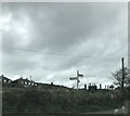
Farm track signs at Penmarth
There are numerous small farms on the slopes of Carnmenellis, served by a network of tracks.
Image: © Rod Allday
Taken: 4 Feb 2011
0.11 miles
7
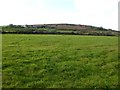
View to Carnmenellis
View across farmland to Carnmenellis.
Image: © Philip Halling
Taken: 7 Nov 2017
0.12 miles
9
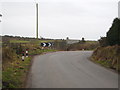
A sharp bend in the road
This minor road from Penmarth to Nine Maidens is very winding and narrow but it is much used as a direct route from the Falmouth/Penryn area towards Camborne.
Image: © Rod Allday
Taken: 4 Feb 2011
0.16 miles
10
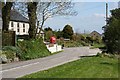
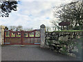
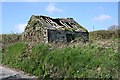
Penmarth Village
Penmarth is a quite small village with a mixture of housing styles and ages.
Image: © Tony Atkin
Taken: 27 Apr 2006
0.16 miles