IMAGES TAKEN NEAR TO
Lanner Hill, REDRUTH, TR16 6DY
Introduction
This page details the photographs taken nearby to Lanner Hill, TR16 6DY by members of the Geograph project.
The Geograph project started in 2005 with the aim of publishing, organising and preserving representative images for every square kilometre of Great Britain, Ireland and the Isle of Man.

There are currently over 7.5m images from over14,400 individuals and you can help contribute to the project by visiting https://www.geograph.org.uk
Image Map (Loading...)


Getting Data...Please wait
Leaflet Map data © OpenStreetMap
Images are licensed for reuse under creativecommons.org/licenses/by-sa/2.0
Notes
- Clicking on the map will re-center to the selected point.
- The higher the marker number, the further away the image location is from the centre of the postcode.
Image Listing (22 Images Found)
Images are licensed for reuse under creativecommons.org/licenses/by-sa/2.0
Image
Details
Distance
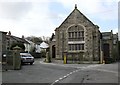
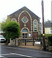
1
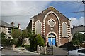
Lanner Village Hall
This seems to be an old Methodist church put to a new use but the blocked up windows at the front of the building give it an air of dereliction.
Image: © Tony Atkin
Taken: 21 Aug 2007
0.04 miles
2
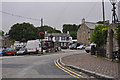
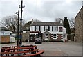
Lanner : Rough Street
Looking along Rough Street with the Lanner Inn in view.
Image: © Lewis Clarke
Taken: 13 Jul 2015
0.05 miles
3
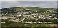
Lanner and Carn Marth
Taken from Chapel Hill to the south of the village of Lanner, this photo looks down on the village and up to Carn Marth above it.
Image: © Tony Atkin
Taken: 21 Aug 2007
0.06 miles