
IMAGES TAKEN NEAR TO
Nancekuke, REDRUTH, TR16 5UF
Introduction
This page details the photographs taken nearby to TR16 5UF by members of the Geograph project.
The Geograph project started in 2005 with the aim of publishing, organising and preserving representative images for every square kilometre of Great Britain, Ireland and the Isle of Man.

There are currently over 7.5m images from over14,400 individuals and you can help contribute to the project by visiting https://www.geograph.org.uk
Image Map
Images are licensed for reuse under creativecommons.org/licenses/by-sa/2.0
Notes
- Clicking on the map will re-center to the selected point.
- The higher the marker number, the further away the image location is from the centre of the postcode.
Image Listing (4 Images Found)
Images are licensed for reuse under creativecommons.org/licenses/by-sa/2.0
Image
Details
Distance
2
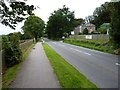
The Bike Barn
A bike hire and campsite business at Elm Farm, which capitalises on the popularity of the converted tramroads which criss-cross this area.
Image: © Richard Law
Taken: 16 Sep 2012
0.09 miles
3
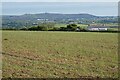
Farmland, Portreath
The monument on Carn Brea is seen in the distance.
Image: © Andrew Smith
Taken: 13 May 2022
0.22 miles
4
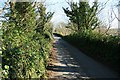
Embankment near Lower Forge
Although it looks like a country lane, this is actually an embankment on the route of the Portreath Tramroad. The embankment crossed a river valley and was the one major civil engineering project undertaken during construction. The lane between the parapets now provides local access to vehicular traffic.
Image: © John Gibson
Taken: 5 Apr 2009
0.24 miles