IMAGES TAKEN NEAR TO
Creegbrawse, St. Day, REDRUTH, TR16 5QF
Introduction
This page details the photographs taken nearby to TR16 5QF by members of the Geograph project.
The Geograph project started in 2005 with the aim of publishing, organising and preserving representative images for every square kilometre of Great Britain, Ireland and the Isle of Man.

There are currently over 7.5m images from over14,400 individuals and you can help contribute to the project by visiting https://www.geograph.org.uk
Image Map
Images are licensed for reuse under creativecommons.org/licenses/by-sa/2.0
Notes
- Clicking on the map will re-center to the selected point.
- The higher the marker number, the further away the image location is from the centre of the postcode.
Image Listing (5 Images Found)
Images are licensed for reuse under creativecommons.org/licenses/by-sa/2.0
Image
Details
Distance
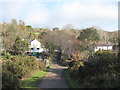
1
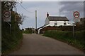
Cottage near road junction
Cottage viewed from the road junction.
Image: © Elizabeth Scott
Taken: 26 Sep 2023
0.14 miles
2
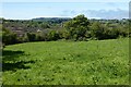
Pasture, Chacewater
On a hillside to the east of Todpool.
Image: © Andrew Smith
Taken: 7 May 2022
0.16 miles
3
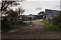
Creegbrawse Farm
The farmyard at Creegbrawse Farm. The name is from Cornish krug, a mound or barrow, plus bras, large. This indicates that there was once a bronze age barrow here.
Image: © Elizabeth Scott
Taken: 26 Sep 2023
0.18 miles
4
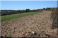
A New Gas Pipeline
The edge of this pasture remains bare after the installation of an underground gas pipe.
Image: © Tony Atkin
Taken: 6 Apr 2006
0.22 miles
5
The Hamlet of Todpool
At the head of the Poldice Valley.
Image: © Rod Allday
Taken: 19 Nov 2008
0.22 miles