IMAGES TAKEN NEAR TO
Little Beside, St. Day, REDRUTH, TR16 5PZ
Introduction
This page details the photographs taken nearby to TR16 5PZ by members of the Geograph project.
The Geograph project started in 2005 with the aim of publishing, organising and preserving representative images for every square kilometre of Great Britain, Ireland and the Isle of Man.

There are currently over 7.5m images from over14,400 individuals and you can help contribute to the project by visiting https://www.geograph.org.uk
Image Map
Images are licensed for reuse under creativecommons.org/licenses/by-sa/2.0
Notes
- Clicking on the map will re-center to the selected point.
- The higher the marker number, the further away the image location is from the centre of the postcode.
Image Listing (5 Images Found)
Images are licensed for reuse under creativecommons.org/licenses/by-sa/2.0
Image
Details
Distance
1
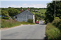
Roadside Cottages at Little Beside
On the road between St Day and Chacewater.
Image: © Tony Atkin
Taken: 7 Jun 2008
0.08 miles
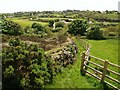
2
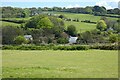
Pasture, Gwennap
The St Day to Chacewater road is seen below.
Image: © Andrew Smith
Taken: 7 May 2022
0.18 miles
3
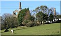
Wheal Bush
Looking across the field towards Wheal Bush Farm with the twin engine houses on Magor's Shaft at Wheal Unity as an appropriate backdrop for this part of the world.
Image: © John Gibson
Taken: 17 Mar 2009
0.22 miles
4
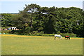
Horses Grazing
A meadow just outside St Day.
Image: © Tony Atkin
Taken: 7 Jun 2008
0.24 miles
5
Poldice valley near Unity Wood
The wall in the foreground borders waste from Image, and this is just southwest of Image A path beside the fence allows access past the engine houses between Image and bridleway 301/13/2, which drops along the other side of the waste heap to meet byway 301/13/2 in the valley at the southern edge of Unity Wood (right). The nearest buildings across the valley are on the site of West Poldice Mine.
Image: © Derek Harper
Taken: 18 May 2009
0.24 miles