
IMAGES TAKEN NEAR TO
Telegraph Hill, REDRUTH, TR16 5AH
Introduction
This page details the photographs taken nearby to Telegraph Hill, TR16 5AH by members of the Geograph project.
The Geograph project started in 2005 with the aim of publishing, organising and preserving representative images for every square kilometre of Great Britain, Ireland and the Isle of Man.

There are currently over 7.5m images from over14,400 individuals and you can help contribute to the project by visiting https://www.geograph.org.uk
Image Map
Images are licensed for reuse under creativecommons.org/licenses/by-sa/2.0
Notes
- Clicking on the map will re-center to the selected point.
- The higher the marker number, the further away the image location is from the centre of the postcode.
Image Listing (11 Images Found)
Images are licensed for reuse under creativecommons.org/licenses/by-sa/2.0
Image
Details
Distance
1
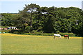
Horses Grazing
A meadow just outside St Day.
Image: © Tony Atkin
Taken: 7 Jun 2008
0.10 miles
2
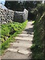
Stone Stile SW7342a
Bunts Lane, mid-way along the footpath.
Coffen stile with gaps between stones filled in.
Coffen stile – a stile built over a pit – like a granite cattle grid.
Coffen is a Cornish word for a man-made hole in the ground.
Public footpath SW226/9/1 gold from Bunts Lane to B3298.
Image: © Lesley Trotter
Taken: 7 Apr 2021
0.10 miles
3
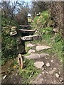
Stone Stile SW7342c
At field boundary.
Cattle stile.
Probably part of Williams’ Scorrier Estate.
Public footpath 226/9/1 gold from Pink Moors Lane to Treskerby.
Image: © Lesley Trotter
Taken: 7 Apr 2021
0.11 miles
4
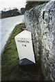
Old Milestone by the B3298, north of Poldice
Carved stone post by the B3298, in parish of ST DAY (KERRIER District), edge of St Day, against old white-washed wall, on West side of road. Erected by the Local Highways Board in the 19th century.
Inscription reads:-
: SCORRIER / STATION / 1½ M : : PENRYN / 7 M :
Grade II Listed. List Entry Number: 1309717
https://historicengland.org.uk/listing/the-list/list-entry/1309717
Milestone Society National ID: CW_PRSS07.
Image: © Ian Thompson
Taken: 10 Dec 2017
0.12 miles
5
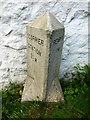
Old Milestone by the B3298, north of Poldice
Carved stone post by the B3298, in parish of ST DAY (KERRIER District), edge of St Day, against old white washed wall, on West side of road. Erected by the Local Highways Board in the 19th century.
Inscription reads:-
: SCORRIER / STATION / 1½ M : : PENRYN / 7 M :
Grade II listed.
List Entry Number: 1309717 https://historicengland.org.uk/listing/the-list/list-entry/1309717
Milestone Society National ID: CW_PRSS07.
Image: © Rosy Hanns
Taken: 4 May 2019
0.12 miles
6

Stone Stile SW7342b
Bunts Lane, where the footpath meets the main road.
Coffen stile with gaps between stones filled in.
Coffen stile – a stile built over a pit – like a granite cattle grid.
Coffen is a Cornish word for a man-made hole in the ground.
Public footpath 226/9/1 gold from Bunts Lane to B3298.
Image: © Lesley Trotter
Taken: 7 Apr 2021
0.12 miles
7
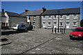
Market Square
This quiet courtyard behind the town clock used to be the bustling hub of St Day market in the time when this village was the commercial hub of the Gwennap mining district.
Image: © Tony Atkin
Taken: 7 Jun 2008
0.20 miles
8
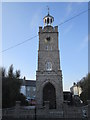
War Memorial Clock Tower
There is an OS cut mark on the granite wall of the Memorial Clock Tower. http://www.geograph.org.uk/photo/4450663
Image: © Adrian Dust
Taken: 20 Apr 2015
0.21 miles
9

Ordnance Survey Cut Mark
This OS cut mark can be found on the wall of the War Memorial. It marks a point 124.526m above mean sea level. http://www.geograph.org.uk/photo/4450667
Image: © Adrian Dust
Taken: 20 Apr 2015
0.21 miles
10
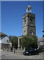
The Town Clock
This clock tower was built in 1831. It is capped by a distinctive bellcote which used to be on Redruth town clock and was erected here in 1904. The ground floor of the tower used to be used as a temporary lock-up to house the drunk and disorderly overnight.
Image: © Tony Atkin
Taken: 7 Jun 2008
0.22 miles