IMAGES TAKEN NEAR TO
Green Lane, REDRUTH, TR16 4NX
Introduction
This page details the photographs taken nearby to Green Lane, TR16 4NX by members of the Geograph project.
The Geograph project started in 2005 with the aim of publishing, organising and preserving representative images for every square kilometre of Great Britain, Ireland and the Isle of Man.

There are currently over 7.5m images from over14,400 individuals and you can help contribute to the project by visiting https://www.geograph.org.uk
Image Map
Images are licensed for reuse under creativecommons.org/licenses/by-sa/2.0
Notes
- Clicking on the map will re-center to the selected point.
- The higher the marker number, the further away the image location is from the centre of the postcode.
Image Listing (73 Images Found)
Images are licensed for reuse under creativecommons.org/licenses/by-sa/2.0
Image
Details
Distance
1
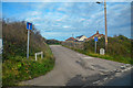
Portreath : Green Lane
Green Lane off the B3301.
Image: © Lewis Clarke
Taken: 2 Dec 2019
0.12 miles
2
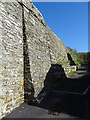
Railway Incline
The incline seems to have been the end of a branch line, presumably for bringing ore to Portreath harbour. There must have been some means of assisting the empty waggons back up, because it looks much too steep for a conventional train.
Image: © Anne Burgess
Taken: 11 May 2018
0.13 miles
3
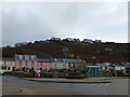
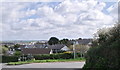
Bus shelter in the centre of Portreath
The village stretches on each side of the river, and up the steep valley sides
Image: © David Smith
Taken: 16 Jan 2014
0.13 miles
4
B3301 junction with road to Illogan near Portreath.
Image: © Colin Pyle
Taken: 6 Apr 2010
0.14 miles
6
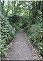
Public footpath
This steep footpath rises from near the eastern end of Primrose Terrace in Portreath and climbs up through woodland to Feadon Farm http://www.feadonfarmwildlife.co.uk/ , which is just a short distance ahead.
For a photograph taken near the start of this right of way, click here Image
Image: © Alan Walker
Taken: 29 Aug 2017
0.14 miles
7
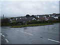
Tregea Hill, Portreath
This picture shows how the terraces of the older settlement were set back at the hillfoot away from the industrialised area of the village.
Image: © Simon Huguet
Taken: 11 Aug 2008
0.15 miles
8
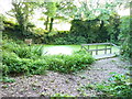
Feadon Farm pond
The pond is attached to the adjacent Feadon Farm wildlife and educational centre http://www.feadonfarmwildlife.co.uk/ and was rescued from a state of some dereliction; it now has a population of dragonflies, butterflies, newts and toads, and assorted native plants.
Image: © Richard Law
Taken: 21 Sep 2012
0.15 miles
9
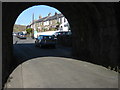
Under the incline, Portreath
Glenfeadon Terrace viewed from under the arch carrying the Portreath Incline, a former trackbed.
Image: © Philip Halling
Taken: 25 Apr 2010
0.15 miles
10
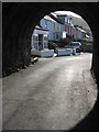
Under the Portreath Incline
Houses on Glenfeadon Terrace viewed from below the Portreath Incline which used to carry a railway.
Image: © Philip Halling
Taken: 25 Apr 2010
0.15 miles